Stevens Canyon Road Rehabilitation Project: Oct 2023
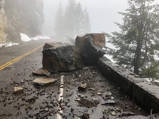
NPS photo

From the NPS website: A multiyear rehabilitation project on Stevens Canyon Road, the only east-west thoroughfare in the park, is underway. The popular Stevens Canyon Road has suffered extensive damage over the years and is in dire need of an overhaul. Contractors will be working on replacing stone guard walls, repairing drainage grates along the roadway, patching holes in the road surface, and more. This is a multi-year project that is anticipated to last through summer 2024.

The road has been closed weekdays Monday-Friday for the 2022 and 2023 season, only allowing access on the weekends. My recent RIMROBOD ride had to take place on a Saturday, and my bike/hike forays of various iterations have been put on hold these past two years with the road closure. What the access status will be in 2024 is a guess; the repairs seem mostly complete. The following video starts just after Stevens Creek and ends at Box Canyon, with a comparison to this section of road filmed on Jun 8, 2016.

RIMROBOD Oct 2023

EDIT: I first did the RIMROBOD (Ride the Interior of Mt. Rainier Out and Back in One Day) ride in 2017 on my old road bike, a Trek 5500. Starting at Longmire, I figured 121 miles with 15,600’ of climbing for the out and back to Sunrise. I recently did the ride, slightly shorter as I started at Cougar Rock campground, on October 7th, 2023. This time I used an altimeter and Strava which produced different stats: although the distance checked at 118 miles, I logged 13,594’ on Strava, and when I imported the GPX file to map the ride the total came to 13,435’ elevation gain. In my original iteration in 2017, I arrived at Box Canyon on the return leg around 9 PM and took a 3 hour nap, finishing in the dark. This time around I used my Salsa Cutthroat, and finished the entire ride at 6:25 PM (started at 5 AM) for 13.5 hours of total time. The Salsa has much better climbing gears and I was able to spin easily up the climbs, conserving energy in the process. 2023 also saw greatly improved cycling fitness for me, which helped tremendously. I am retiring my original video of RIMROBOD with this more recent iteration with more accurate stats. Also, my 2017 ride was in July, a week before RAMROD (Ride Around Mt. Rainier in One Day), but I must say the fall colors were a poppin’ for this October ride and made for extreme eye candy and olfactory bliss, highly recommended! Hopefully, the Stevens Canyon Road will be open during the week sometime in 2024, as doing this ride on a weekend involves serious traffic.

MRNP: RIMROBOD Century (Oct 2019)

This year I’ve done two iterations of RIMROBOD (Ride the Interior of Mt. Rainier Our and Back in One Day); the Short Course and the Century. RIMROBOD avoids all the garbage miles of RAMROD (Ride Around Mt. Rainier in One Day) and stays within the confines, either climbing or descending all the while taking in the varying views of the eye popping terrain as you cover 100 miles and climb 11,400 feet. I parked at Box Canyon and proceeded towards Sunrise, climbing in quick succession to Backbone Ridge, Cayuse Pass, Chinook Pass and Sunrise, reversing and continuing past my vehicle after a caffeine infusion towards Reflection Lake, descending this last segment under bike lamp. This turned out to be basically the end of the season, with snow soon after closing the Sunrise Road and winter conditions settling in the middle of October. The following tightly edited video provides snippets of milestones within 13 minutes.


Biking Rainier: Misc. Rides

This video covers rides not included in the major climbs and descents in the park. Most of this footage was shot when the roads were not open to public vehicles, including the short section from Highway 410 to Mt. Rainier's White River entrance. To target viewing, the following lists the specific sections and minute marks:

1. Lower West Side Road: This first 3 miles of the road, with 1000 feet of climb, is usually open in the summer season. Filmed before the gate was open on a sunny April day: 00:00 - 09:27

EDIT OCT 2023: See the 2023 timelapse of the entire West Side Road below from its end at Klapatche Point to the main road intersection.

2. White River Campground to White River entrance: filmed when road crews had plowed and were in the process of clearing debris, but otherwise void of people, a good time to access these areas of the park before vehicles are allowed: 09:27 - 27:53

2A. Highway 410 to White River entrance: filmed during the low snow year of 2015 on February 11: 27:53 - 32:57

3. Chinook Pass to Cayuse Pass: Chinook Pass marks the northern entry to the park on Highway 410, and descends over 3.5 miles to Cayuse Pass, losing 800 feet. Cayuse Pass is also the intersection with SR 123, taking the rider south on the eastern side of the park: 32:57 - 41:58

OVERVIEW and STATS: 42:00 - 43:15

This last video in the "Biking Rainier" series fills in some of the park roads not covered in the major climbs. Following is a breakdown with minute references to view each ride. Most of this footage was shot when the roads were not open to public vehicles. 1. Lower West Side Road: the first 3 miles of the road usually open in the summer 00:00 - 09:27 2. White River Campground to White River Entrance 09:27 - 27:53 (Highway 410 to White River Entrance) 27:53 - 32:57 Chinook Pass to Cayuse Pass 32:57 - 41:58 Overview and Stats 42:00 - 43:15

Smooth pavement characterizes this short 5.5 mile section from Longmire to the West Side Road with an elevation loss of 600 feet.

Shortly after entering the park at the Nisqually entrance, one passes the turn off for the West Side Road. This segment covers the gentle grade from Longmire to the West Side Road, a total of 5.5 miles and a 600 foot loss. Recently repaired, improved, and repaved, this is a smooth ride and portends the section, hopefully finished this year (2017), of the Longmire to Paradise road.


Biking Rainier: Highway 410

Highway 410 transits the northern part of Mt. Rainier National Park, starting at the Crystal Mountain turnoff and ending at Chinook Pass. This video begins at Cayuse Pass and ends at the park boundary, with the last part of the video filmed in February of 2015, an unusually low snow year. Highway 410 was closed to vehicles for the winter but the road was clear of snow, allowing me to venture into the park via the White River entrance and even day hike to Summerland, practically impossible in a normal snow year. The first part of the video was filmed on June 8, 2016, covering the 3 miles and 1000 foot descent from Cayuse Pass to the White River entrance to the park. The grade on Highway 410 allowed for some consistently higher speeds versus some of the other bike rides I have captured.

Highway 410 transits the northern part of Mt. Rainier National Park, starting at the Crystal Mountain turnoff and ending at Chinook Pass. This video begins at Cayuse Pass and ends at the park boundary, with the last part of the video filmed in February of 2015, an unusually low snow year. Highway 410 was closed to vehicles for the winter but the road was clear of snow, allowing me to venture into the park via the White River entrance and even day hike to Summerland, practically impossible in a normal snow year. The first part of the video was filmed on June 8, 2016, covering the 3 miles and 1000 foot descent from Cayuse Pass to the White River entrance to the park.

Biking Rainier: Sunrise Park Road

Mt. Rainier's Sunrise Park road is a moderate but fun climb and descent, especially if the timing is right. I updated the original video from 2016 to this current 4K video filmed on June 27th, 2023, before the road was officially opened to regular traffic. This current video was filmed using 3 cameras, a helmet mounted GoPro Max 360, a chest mounted GoPro Hero 11, and a bike mounted rear facing GoPro Hero 9. The video was authored in Ultra Wide format, so make sure you expand to full screen for best viewing.

Biking Rainier: SR 123

SR 123 is a seasonal road only open during the summer months. It connects Highway 410 to the north to Highway 12 in the south. This video starts at Cayuse Pass and descends 2600 feet over 11 miles to the Park's Stevens Canyon entrance. Highway 123 is part of the RAMROD route (Ride Around Mount Rainier in One Day). Filmed on June 8, 2016.

Situated on the east side of the park, SR 123 connects Highway 410 on the north to Highway 12 on the south side. This road is open only during the summer months, and is the only way to circle the park. This ride, filmed June 8, 2016, begins at Cayuse Pass and descends 2,600 feet to the Stevens Canyon entrance to Mt. Rainier National Park (11 miles).

Biking Rainier: Stevens Canyon Road

Mt. Rainier National Park has some of the best bike climbs and descents in the state. The Stevens Canyon Road ranks right up there, with 3400 feet of descent, starting at the junction with the Paradise road, interrupted by a 700 foot climb to Backbone Ridge, then continuing on to the Ohanapecosh (Stevens Canyon) entrance and intersecting SR 123 for a total of 18 miles. The first part of this video was filmed on May 2, 2016 before the road was open to vehicular traffic. The rest was filmed on June 8, 2016. I'm using a mountain bike to keep speeds reasonable, topping out at about 35 mph.

This video transits Mt. Rainier's Stevens Canyon road from the intersection with the Paradise road to the Ohanapecosh entrance in the southeast corner of the park. When biking east, there is one climb over Backbone Ridge of 600 feet but otherwise enjoys 4200 feet of downhill romp over 18 miles. The first part of this video was filmed on May 2, 2016 before the road was open to vehicular traffic. The rest was filmed on June 8, 2016 as part of a 77 mile, 8,000 foot climb day, all within the park boundaries.

Biking Rainier: Paradise to Longmire

Mt. Rainier is a training ground for many things but the biking is sometimes overlooked, except for the annual RAMROD event (Ride Around Mt. Rainier in One Day). I like to sometimes bike from Longmire to Paradise, a 2600 foot climb, perhaps hike to Camp Muir (at 10,100'), and be rewarded at the end of a hard day by the wonderful downhill bike from Paradise to Longmire. This is best done early or late in the day during the summer, or on an off time like this video (mid week Feb 26) to mitigate traffic problems. In the winter the gate to Paradise is opened at 9:00 AM so all the traffic is uphill. Taking advantage of sparse downhill traffic at around noon, I used 3 cameras mounted Left (Contour Roam2), Center (GoPro Hero2), and Right (GoPro Hero3 Black Edition) to capture this entire 11 mile journey. I use a mountain bike to keep speed reasonable and the fatter tires cope with rough roads, cracks or detritus easier than my skinny tire road bike. Shot in 960 Tall on each camera.

Biking Rainier: West Side Road

Mt. Rainier National Park's West Side Road was originally envisioned as part of a motorcar road that would encircle the entire mountain. This idea was eventually abandoned, dynamiting the bridge that spanned the North Puyallup River and, late 80’s, letting the road from Klapatche Point to the North Puyallup Camp revert to trail status (I used to day hike this area driving to the North Puyallup parking lot, 1983-1987). This video is an update (and significantly shorter) than the original filmed in 2012. Using a chest mounted GoPro Hero 11, I “hyperlapsed” the entire road in one shot, starting from its end at Klapatche Point to the start at the main road intersection, just inside the park entrance. Filmed in 4K on October 19, 2023.

Biking Rainier: Ipsut Creek Road

The Ipsut Creek Road was once driveable its entire 5 miles, with the Ipsut Creek campground a drive in akin to Cougar Rock or Ohanapecosh. After two major flooding events the road has been converted to trail status, open to hiking and biking. This video was recorded on April 29, 2012. As of this writing (June, 2016) the trail has suffered more damage and some parts will be more difficult to transit on bike.

The 5 mile road from Mt. Rainier National Park's Carbon River entrance to the Ipsut Creek campground is forever closed to vehicular traffic but remains open as a bike/hike trail. Biking this trail is the fastest way to do the 17 mile round trip to the Carbon Glacier, plus the easy grade makes for a very pleasant ride. This tour shows all the different parts of the trail in a descent ride, edited for time by cutting out some of the cruising sections where the prior road is still in good shape. This was filmed on April 29, 2012. Filmed with a Contour Plus at 60 FPS mounted to the frame.

5 years later with mother nature keeping things in flux, this update (filmed on May 26, 2017) shows the entire trail with no time editing......23 minutes to cover the entire 5 miles.

This short video highlights some of the biking opportunities at Mt. Rainier National Park.