Willis Wall

CELEBRATE THE OUTDOORS

40 years outdoors experience, extensive info on Mt. Rainier’s Wonderland Trail, original music, equipment reviews, off trail videos, other peaks in Mt. Rainier NP

  • About
  • Wonderland Trail
    • Willis Wall's Views on the Wonderland Trail
    • Wonderland Trail: Complete Video Series
    • Wonderland Trail Backcountry Camps
    • Alternate Wonderland Trail Camps
    • The Northern Loop Trail
    • Wonderland in 13 Minutes CCW
    • Wonderland Enhancement Videos
    • Early Season Challenges
    • Wonderland Shorts
    • Hiking the Wonderland Trail (2006 DVD)
    • My Wonderland
    • Wonderland Trail Post 2006 flood (2007)
    • Pain and Suffering: Wonderland Trail in 3 Days
    • Wonderland Trail 2010: the "selfie" 3 day hike
    • Wonderland Trail Transits 32-37
    • Western Loop
    • Mowich Rivers 2023
    • Mowich Rivers 2012
    • Annual Compilations
    • Wonderland Trail Photo Gallery
    • Mt Rainier 7Up Hikes
    • Filming the Trail
    • Past Updates
  • Willis Wall Blogs
    • Willis Wall Blog
    • 60
    • Blog Posts Reference
    • 68/35
  • 35 Years in MRNP
    • 35 Years in MRNP
    • Mt. Rainier Hikes 2018
    • Mt. Rainier All Trails gallery
  • 360 Videos
    • 360 Videos
  • Grand Tour (MRNP)
    • Grand Tour (MRNP)
  • Travel
  • Off Trail
  • Video Guide
    • Complete Video Guide
    • Biking Mt. Rainier
    • Eliot Creek Crossing: Timberline Trail
    • Paradise to Camp Muir
    • Hurricane Ridge Road Bike
    • Mt. Baker Highway 542 bike
    • Washington Pass Bike (Cascades)
    • Mowich Lake Road
    • Films under construction
  • Shorts
    • On The Rocks
    • The Spit
    • Enchanted Valley Chalet Tour
    • Look Up!
    • Wonderland Short: Jaunt to Summerland
    • Wonderland Short: 2011
    • Wonderland Short: 2015
    • Wonderland Short: Emerald Ridge
    • Wonderland Short: Frozen
    • Wonderland Short: Stevens Canyon washout area
    • Mt. Rainier West Mini Loop
    • Longmire to Muir to West Side Road
    • The Hummock
    • Peakaboo
    • The Other Campground
    • West Side Road
    • Carbon Glacier
    • The Seattle Viaduct (SR99)
    • Off Trail
    • Lane Peak Gully
    • Sunshine Point
    • Chasing Turbo
    • Mt Kilimanjaro
    • Rainier in Fall
    • Skyline Trail Improvements
    • Old Black Diamond
    • Left of Spring
  • Music
    • Music
    • Audio Samples
    • Anthology
  • Search
  • Contact
    • Contact Willis Wall

Wet flora pervaded on my Wonderland Trail hike #36

Wonderland Trail YoY(o) August/2024

September 01, 2024 by Willis Wall

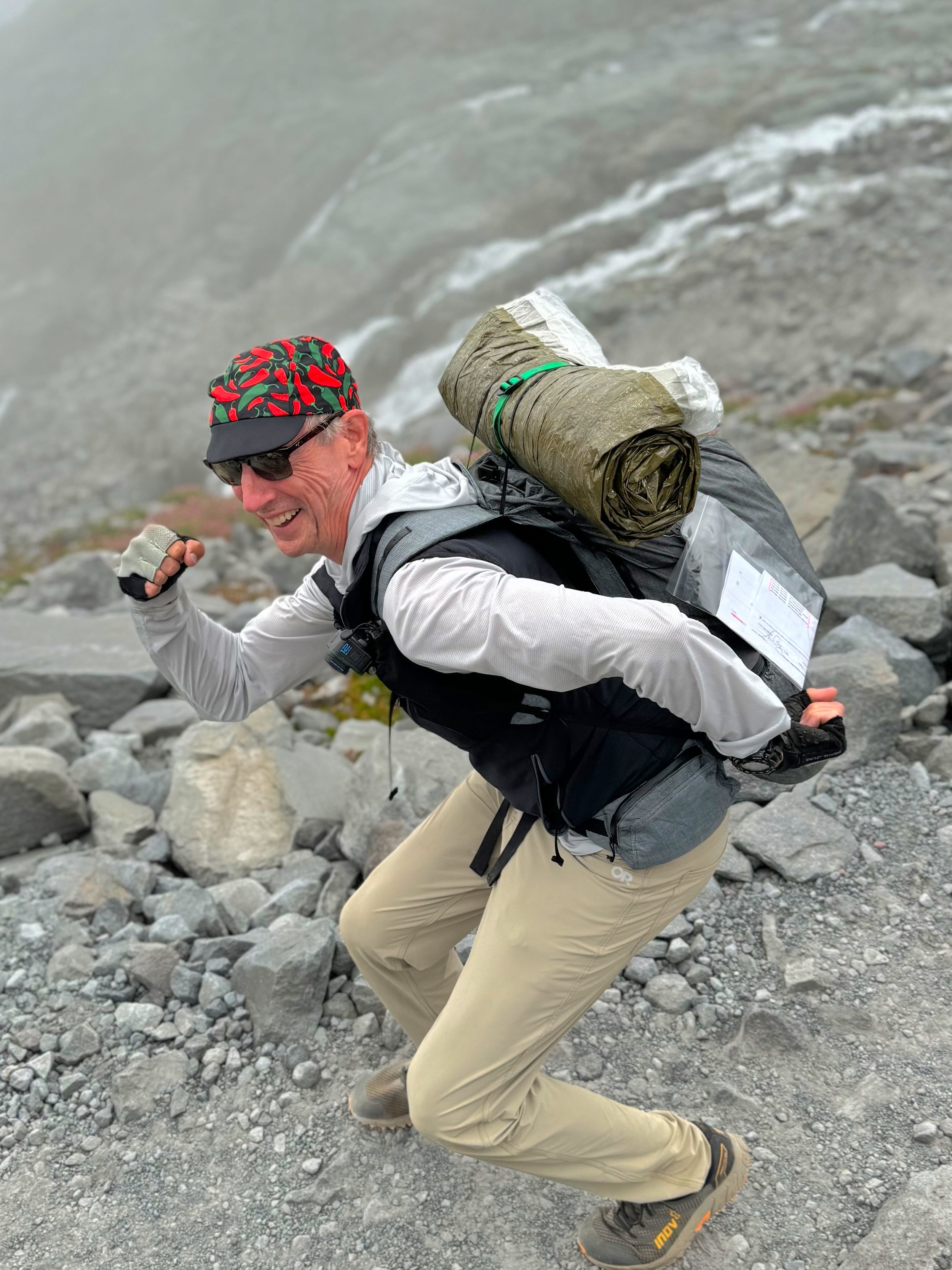
Willis Wall under a 13 lb load (utilizing a Blizzard Survival Tube)

Why the strange title? Well, the first “Yo” went well, starting from Longmire and proceeding CCW, finishing Wonderland Trail #36. However, weather was wonky and I delayed my permit an extra day hoping for a better forecast. Didn’t happen, as the second “Y(o)” had to be cut short after the second day (2/3) of a CW circuit. In sum, when one is hiking in rain and continuous wet weather, trying to cover 30 miles with no chance to stop and dry out the feet, well…I ended up at White River with macerated heels and blisters forming. Although physically I was good for the last day, the condition of my feet was not prime for a 33 mile day in continuing wet conditions. I pulled the plug and got a ride back to my vehicle in Longmire from a buddy who was camped at White River. My new plan was to return in better weather and complete that last section, White River to Longmire, to complete Wonderland Trail #37.

THERE ARE TWO VIDEOS AT THE END OF THIS POST FOR WONDERLAND TRAIL HIKES #36 AND #37

INTRO: I decided on attempting a YoYo this year, trying to capitalize on probably my best fitness level in some time. The foundation was laid by 2 years of consistent and targeted cycle training, culminating in my cross Pyrenees bike trip. Then it was 6 days hiking on the GR10, followed by a leg tuner on Mt. Rainier’s Western Loop. These activities put me in good stead to pull off two 3-day Wonderland Trail hikes, planned with one day of rest in between. I departed on the CCW loop from Longmire on August 14th.

Rare sun break in Ohanapecosh Park, Wonderland Trail

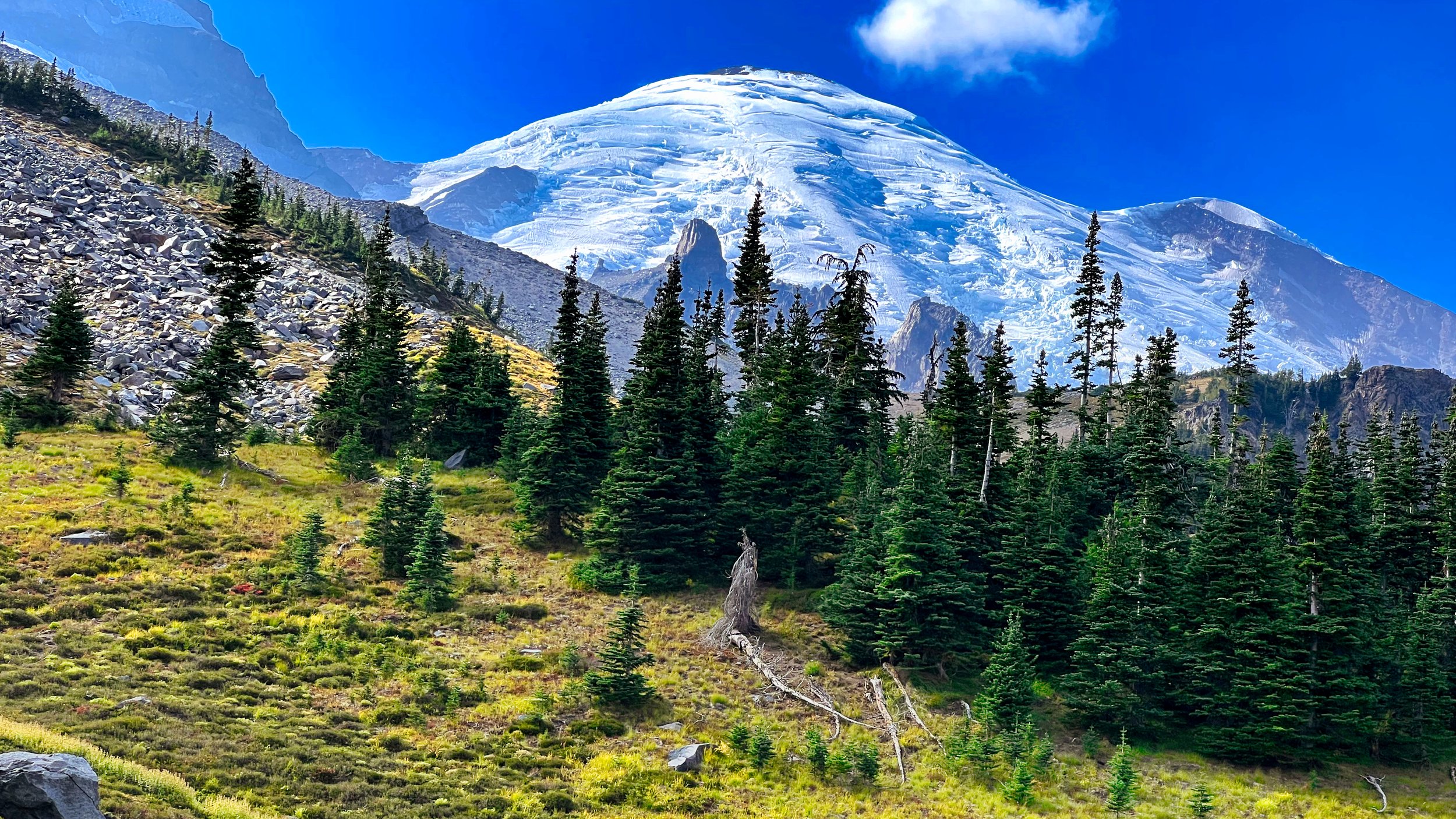
August 14: DAY 1 (36 miles/10,900’) I hit the trail at 5:30 AM. Although I never encountered rain, the skies were cloudy and offered just one momentary view of the tippy top on the mountain, just above Indian Bar. However, the day was dry and I enjoyed myself hiking this section, even the slight grind at the end of the day to Sunrise camp. I had lively encounters with hikers along the way and these conversational breaks fit into my schedule perfectly.

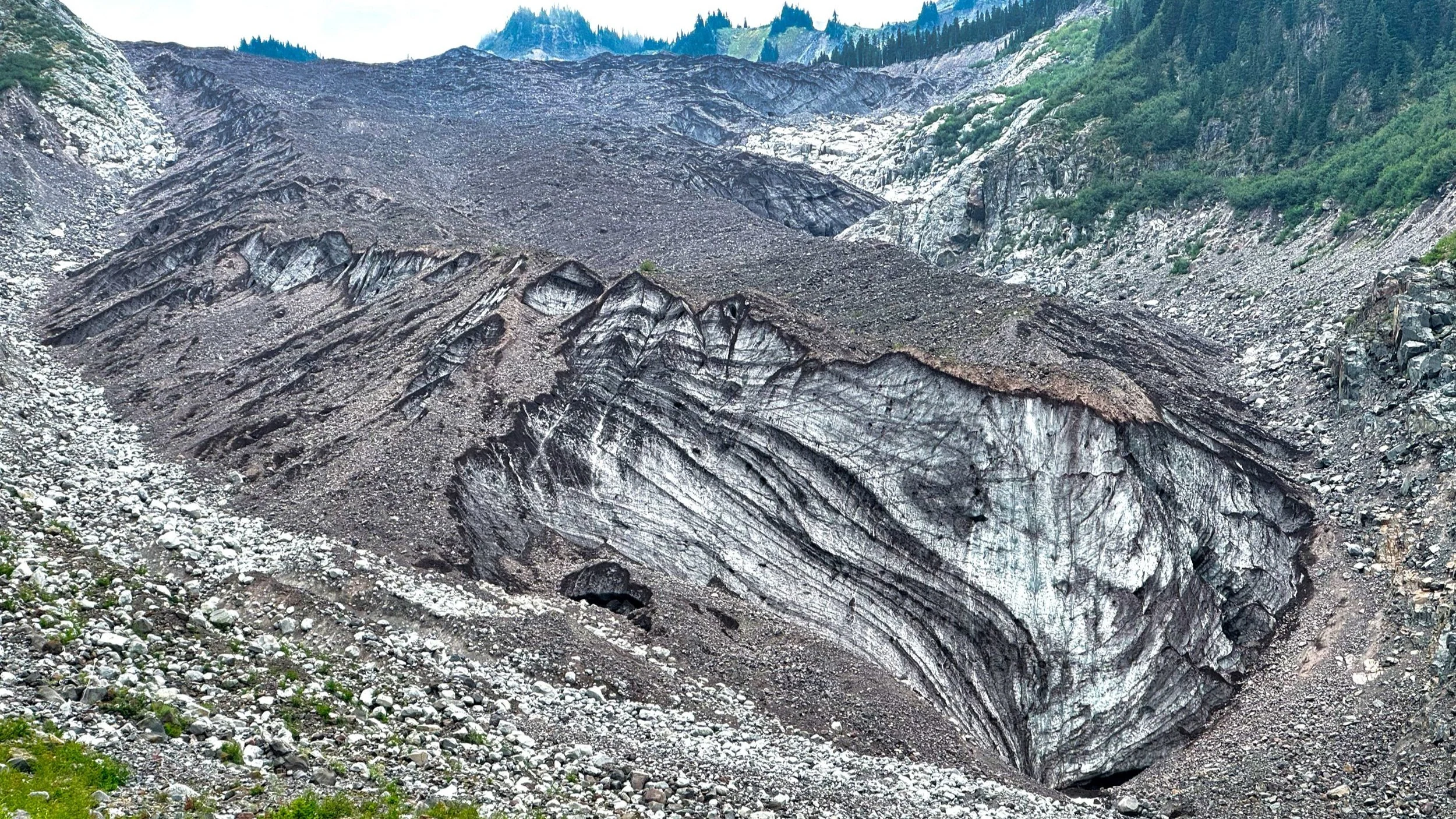
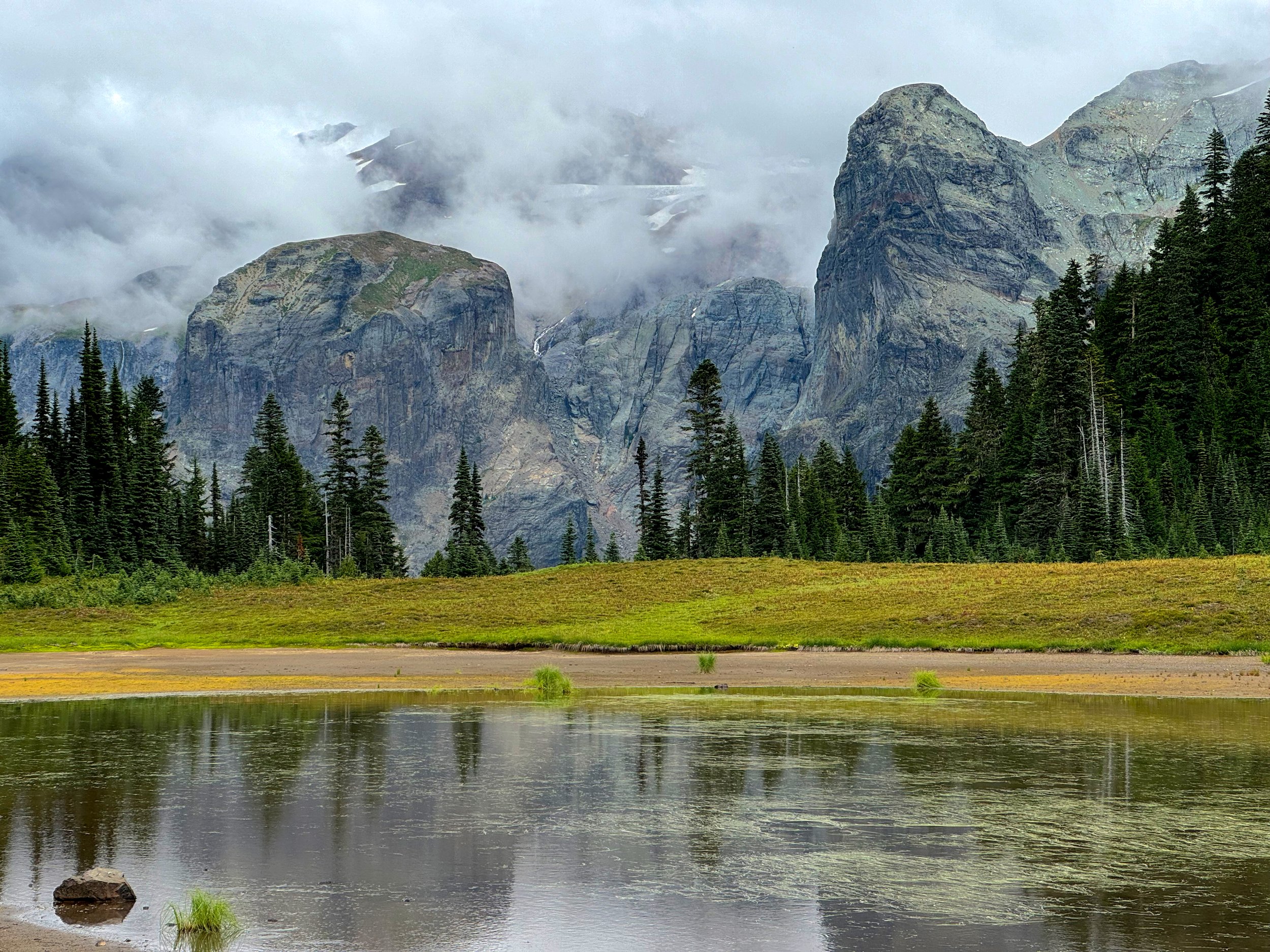
Carbon Glacier, Mt. Rainier National Park

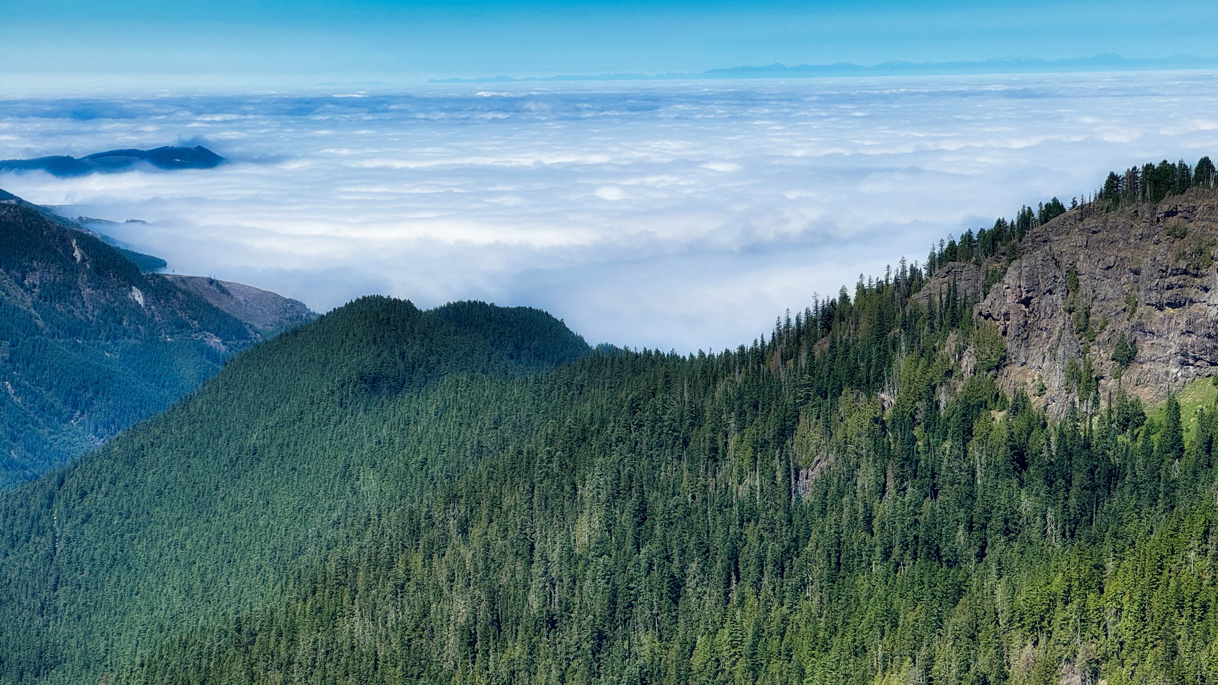
August 15: DAY 2 (44 miles/8,900’) This was my longest day this year, but things went well and I was able to motor consistently to 2 AM. Most of the day I was hiking in the marine layer with fog and limited views, and eventually this presented my lower legs with the dreaded wet, overhanging soaking grass and brush. No amount of beating the flora with poles ahead can stop the infiltration of feet seeking moisture missiles.

Emerald Ridge, Wonderland Trail

August 16: DAY 3 (27 miles/6,100’) The wetness continued well into the afternoon, passing a socked in St. Andrews Lake. However, by the time I was climbing to Emerald Ridge, things had dried out for some nice views below the cloud layer. This respite from moisture came to a screeching halt with the crossing of Kautz Creek, a knee deep, short but rushing silt laden torrent. Thankfully this occurred before nightfall, as navigation through this area is not well marked. Although I have high familiarity with the trail, some of these river crossings change dramatically year to year so past reference is sometimes irrelevant and can actually lead me astray (“well, this is where it USED to be”). By the time I reached the dreaded sign atop Rampart Ridge announcing that there’s still 2 miles to Longmire, my shoes had at least stopped making squishing noises. Thankfully there was no damage to my feet. Another Wonderland was in the books!

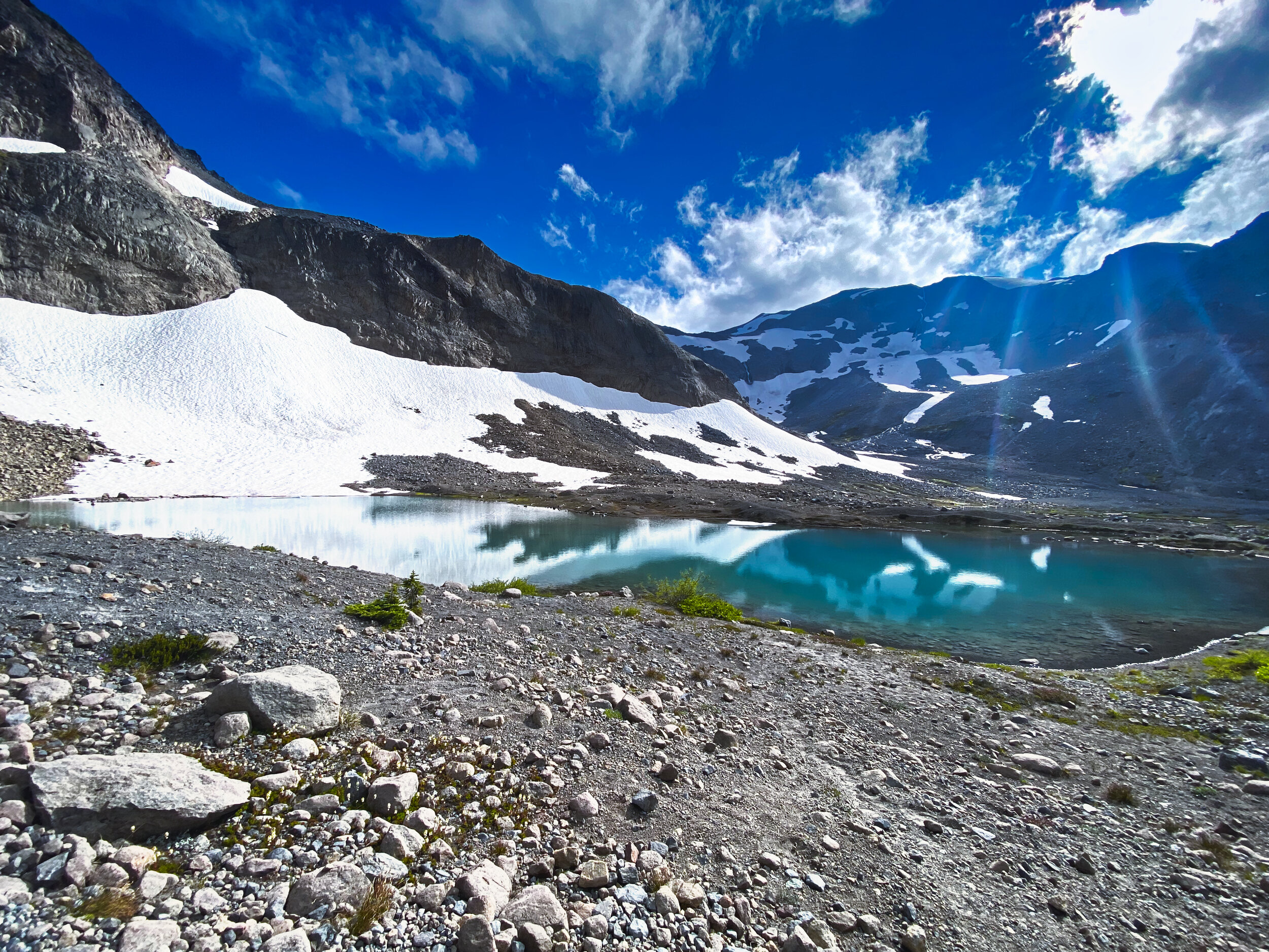
Sky reflection in Kiya Lake

August 19: Y(o)…DAY 4 (31 miles/8,400’) I left Longmire after two down days with the hopes that the weather would cooperate for the CW loop. This first day proved to be good, in that there was no rain. The lack of views of the mountain was not a deterrent to the cool views below the cloud bases. The skies were opening up a bit and I enjoyed a fabulous sunset at Golden Lakes, chatting it up with 4 men taking in the ambience after their swim. I bid them adieu and trotted off for the South Mowich River camp, knowing that it would be dark by the time I transited the Mowich River crossing. At least this time I knew where the bridges were from just a few days ago, and there were no problems making my way to the camp. I settled in at site 2 in my cozy bivy setup, and even woke to a moon shining through the trees early in the morning. It looked like it was going to be a good day!

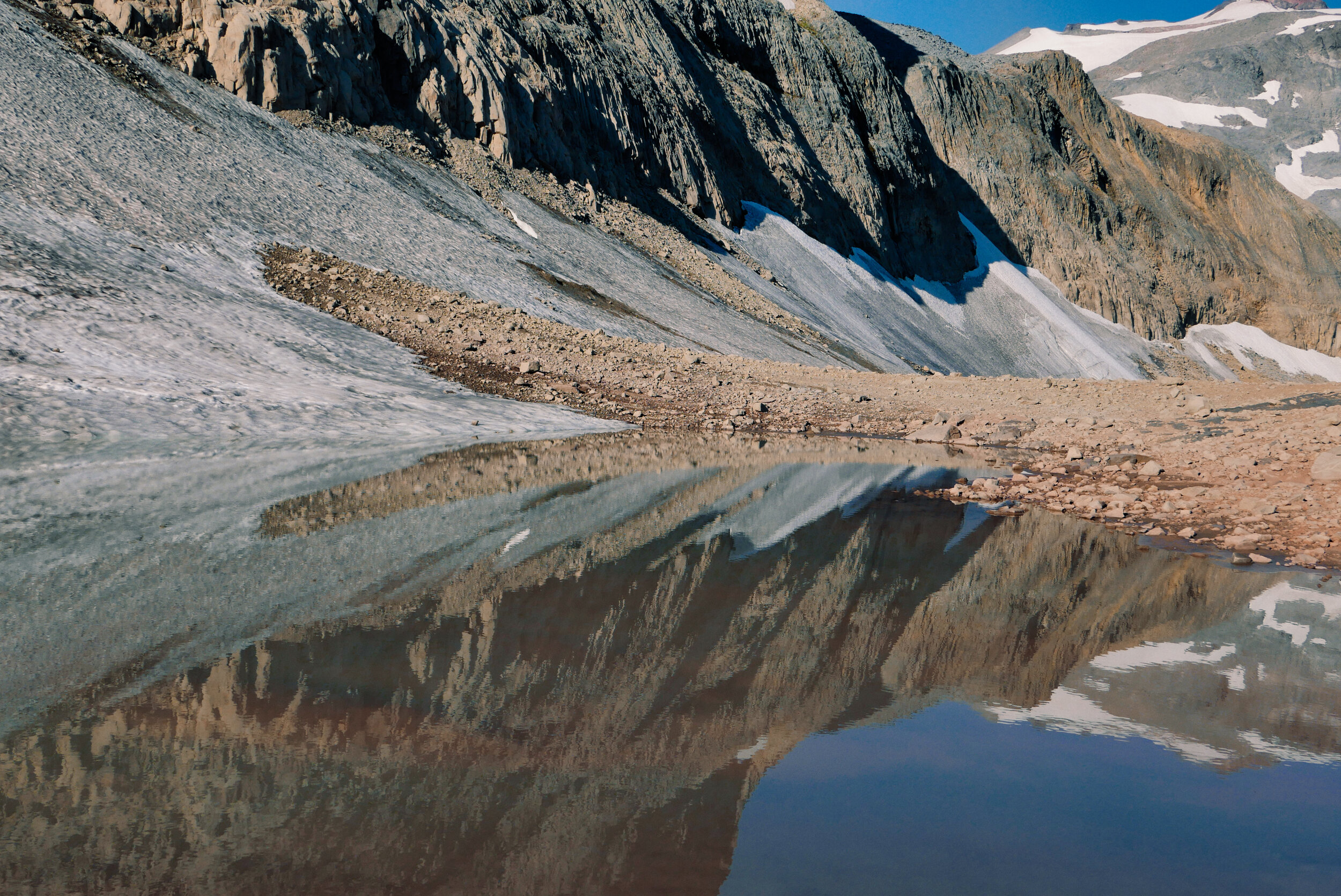
Aurora Lake, Klapatche Park

August 20: DAY 5 (30 miles/9,200’) Sure, it started out OK, with a good temperature and dry conditions on the climb to Mowich Lake. I donned my Rocky Socks in anticipation of gross brush from Ipsut Pass. As I was talking to my video camera about how the only thing that could be worse than the wet brush soaking my legs, sometimes obscuring the feet grabbing wet rocks hidden beneath, would be if it were raining. Bingo! Here comes the rain, and once in the forest I donned all my rain gear, including pogies and rain pants, which I seldom wear (or pack, for that matter). I figured the rain pants would help dry my soaked pants underneath, and this proved to be true; body heat did the trick. But I can’t stand wearing rain pants and took them off at the bottom of the descent, figuring I’d rather just deal with wet legs. I didn’t take many photos the entire day as I was damp…all the time. Hiking in the middle of a cloud made for 100 foot views. I hit Skyscraper Pass while it was still light but turned on the headlamp at Frozen Lake, feeling the damage that was being done to my feet from being wet all day. The Rocky Socks work well, I’ve used them for years, but internal moisture builds up over 16 hours and maceration was taking its toll. When I arrived at White River I knew I could not continue with the blisters that had started to form, especially over 33 miles and another wet day. I had to call it. A buddy of mine was there and the next day he gave me a ride back to Longmire.

Mystic Lake; typical views for most of day 5 of my YoYo attempt

The crappy weather plaguing the area finally came to an end with a good forecast from August 28th on. I made my plans to finish off that last section and drove to the park on Tuesday, August 27th and secured 4 nights at Cougar Rock Campground, which is just shy of two miles from Longmire. I walked down to Longmire on the Wonderland for a coffee stop and WiFi check, which technically covered that last bit of the Wonderland that I would miss by being at Cougar Rock. The plan: bike from Cougar Rock the next day to White River, get some sleep, and hike that final section from White River to Cougar Rock the following day.

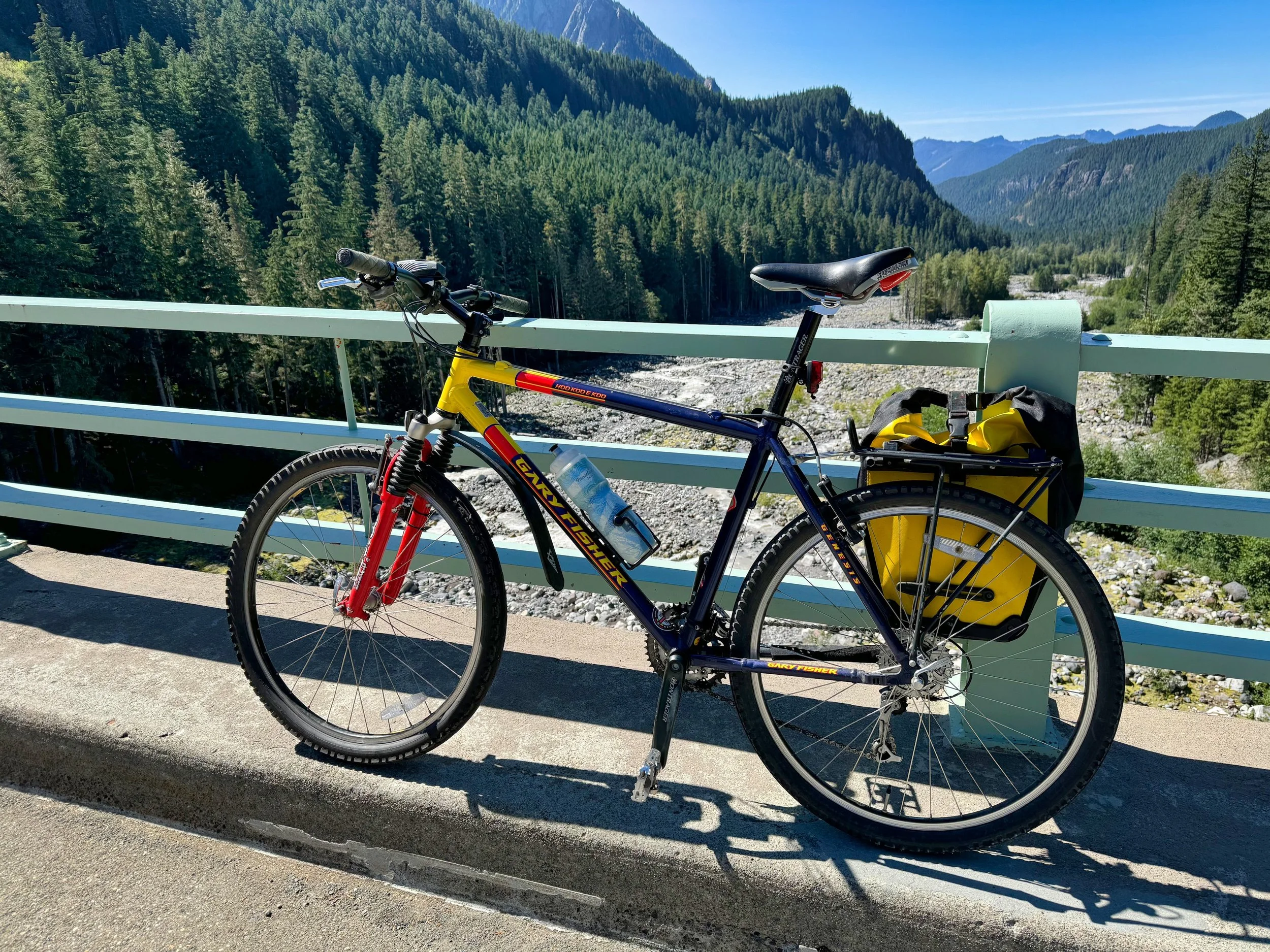
My vintage mountain bike used for positioning from Cougar Rock campground to White River

August 28: Positioning DAY (47 miles/5,600’) Timing was a factor for this bike trip; I did not want to be on the roads after dark, plus I did not want to be entering the White River entrance before the 3 PM timed entry cutoff. Bicycles are exempt from the timed entry, but it is uncool to ride to the head of the line and I didn’t want to spend time in a queue. Therefore I slept in and left at 11:30 AM, figuring it would take about 6 hours to cover the distance based on prior experience (RIMROBOD). I was using my vintage Gary Fisher mountain bike (for leaving in the woods) and I had the extra weight of minimal overnight gear and 2 days of food. The timing, however, was spot on and I entered the park around 5:30 PM. After finding a suitable spot shy of White River where I could park (for the retrieval) and stash the bike, I walked up to White River. Thumb twiddling and napping ensued until I finally set off just past 4 AM for the hike.

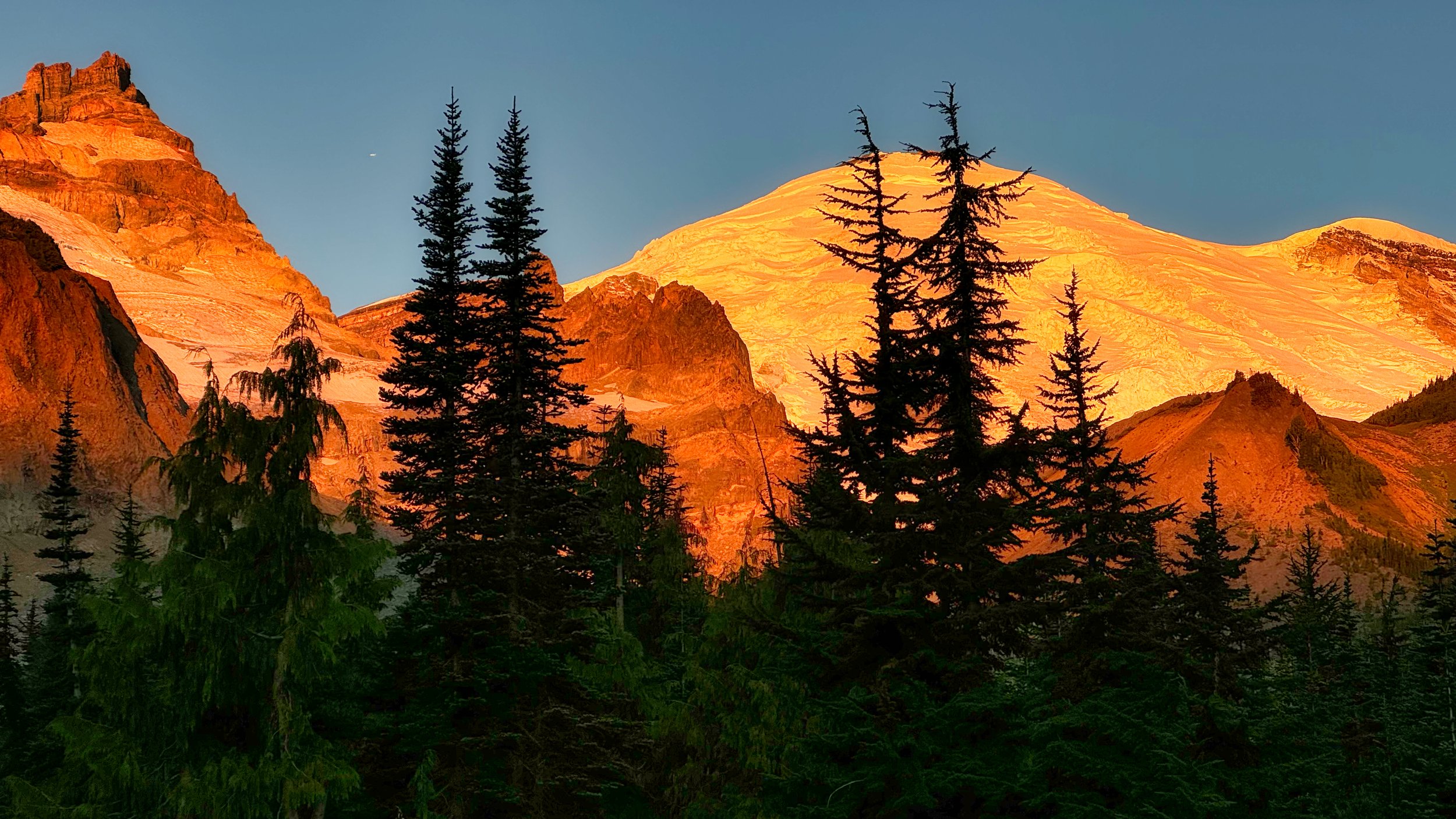
Morning alpenglow at Summerland

August 29: White River to Cougar Rock Campground (31 miles/7,300’) What a difference gorgeous weather makes. DRY feet, crisp air, alpenglow and sunrise. I was closing in on Summerland around 6 AM with the mountain dressed in pinkness, revealing just a little more as I climbed higher. No one was astir, so I had the views to myself. I’ve always maintained that some of the best experiences on the trail are those off times, early and late, when most backpackers are in their tents. The sun was finally cresting when I went over Panhandle Gap, and my transit across Ohanapecosh Park was sublime. This was making up for all the misery and wetness I had experienced prior, and it was still morning! Essentially I breezed through the day, my legs hardened with all the elevation gains and losses accumulated over the prior month, both on trail and in the saddle. I hiked the portion between Maple Creek camp and Reflection Lakes with a newfound trail buddy, Sarah. This distracted both of us from the long climb involved in that section, and Sarah was glad to have me along for negotiating the bypass of the recurring washout area. We parted ways as she departed for Snow Lake; the only downer after that were the scores of people ignoring the ropes at Reflection Lake and tromping all over the shoreline. Otherwise, my earlier prediction of arriving before dark was spot on, ending with me having at beer at my camp spot picnic table whilst waiting for the hot water to gin up in the van, done at 7:15 PM. I had Wonderland Trail #37 in the books, albeit not exactly according to my YoYo plans. Nevertheless, this was truly one of the most interesting outings I’ve had in the park, for many different reasons. Happy Hiking everyone!

September 01, 2024 /Willis Wall
wonderland trail trip reports, wonderland trail in 3 days, hiking the wonderland trail

Mt. Rainier from the Kautz Creek Trail

Mt. Rainier Western Loop

August 10, 2024 by Willis Wall

Mt. Rainier’s Western Loop: 35 miles/8300’ elev

Each year I do an excursion to pummel my downhill legs prior to a 3 day Wonderland Trail hike. Last year that was the Northern Loop Trail, which was especially hard because I had done no hiking the month prior. That 38 miles with 9800’ of elevation gain was a tough one, taking me 18 hours to finish. It did the trick though, and my method has proven itself over many years. Of course, this is assuming one has an excellent fitness base to work from. NOTE: A video chronicle is at the end of this post.

This year I decided on a slightly easier hike, that being the Western Loop in Mt. Rainier National Park. Now, the Western Loop is not an official or even unofficial trek in the park, it was something I came up with in 2016 to complement other loop hikes. That blog, titled “How to Experience Mt. Rainier in Short Segments”, was written to aid hikers in dealing with only walk up permits that year. It was my aim to describe various hikes around the park where one could experience the best parts of the Wonderland, and more.

Because the Western Loop involves using the West Side Road for the return trip, the aim of the hike is to cover the glorious western part of the trail, one of the loveliest sections and most remote, during the daylight hours and utilizing the road for a relatively fast return. However, stashing a bike is almost mandatory, as the last 6 miles involve 3 more miles on the West Side Road and 3 miles on the main drag to return to the starting point, Kautz Creek trailhead. It works, however, and sometimes you just have to think out of the box.

Cloud Sea in the lowlands

On August 6th I stashed my bike at the parking area of the West Side Road, then drove to the Kautz Creek trailhead to begin my hike at 5:30 AM. This trail is 5.7 miles, intersecting the Wonderland Trail at Indian Henry’s Hunting Ground. From there I proceeded CW over Emerald Ridge and St. Andrews Park, ending this portion of the trip at the North Puyallup camp.

Lillies on the Kautz Creek Trail

Let the return phase begin; I hiked the 3 mile North Puyallup Trail to gain the West Side Road, then trotted the road (utilizing the shortcut to Round Pass via the Round Pass Trail) to the parking area where my bike was stashed…this road walking phase was 9 miles. Then it was coasting 3 miles down the West Side Road to the intersection with the Longmire/Paradise road and a mild 3 mile ride back to my vehicle. All in all I traveled 35 miles over 16 hours to complete the loop. Consider that my trail hiking was 11 hours, so the majority of my day was spent reveling in the western part of the park. I even took well over an hour at St. Andrews Lake relaxing and talking to other hikers, and leisurely hiked the last bit from St. Andrews Lake to North Puyallup engaged in lively conversation with hiker Julia.

“The Sign” above Klapatche Park, Mt. Rainier

As I write this it is 4 days later; I am still sore. This is a good thing, as I know the legs will be prepared for multiple days of 8000’ of elevation gain and loss. These “shock” sessions really work. One must consider that I have an extensive cycling base (I recently cycled across the Pyrenees) and my hiking base is OK, having hiked 6 days on the GR10. This difficult day of hiking was the last phase of my preparations.

August 10, 2024 /Willis Wall
mt rainier western loop, mt rainier west side road, hiking the wonderland trail

The view from Summerland, Mt. Rainier National Park

A Jaunt to Summerland and 360 video

September 27, 2022 by Willis Wall

After my grueling 3 day Wonderland Trail hike this year, I spent a few sedate days at White River Campground in Mt Rainier National Park just enjoying the fine weather and relaxing. However, on that Thursday September 22nd I decided to run up to Summerland to capture some 360 video. At the current state of 360 affairs, I believe that 360 is best realized for the viewer on a VR headset. Most 360 editors are still presenting on a single screen where they decide where the camera points. I am still experimenting with the format and its possibilities, and in this iteration I authored in split screen, allowing the viewer to see a large swatch of the environment simultaneously. See this shorter version (2:40) for a single screen traditional viewing.

I experimented with wide screen formats 10 years ago by making a custom mount and using 3 cameras. “Walkin’ the Wonderland” is one production which showcases this. With the excellent stabilization of the newer GoPro cameras production values are certainly improved. I have opened comments for this blog article is anyone wants to weigh in on their viewing experience. Bach arrangements by Willis Wall. Happy Hiking!

September 27, 2022 /Willis Wall
wonderland trail, summerland, summerland camp mt rainier, hiking the wonderland trail, 360 video
1 Comment
The “Green Tarn” above Summerland

The “Green Tarn” above Summerland

Wonderland Trail in 3 Days: Jul 20-22/2021 (#33)

July 25, 2021 by Willis Wall

Once again I am thankful to be healthy enough to pull off another 3 day transit of Mt. Rainier’s Wonderland Trail. Most of my past Wonderland hikes have been in the fall, so this circuit in July provided some significant contrasts. The longer days meant I spent most of my trail time sans headlamp, putting in 14-15 hour days. I was able to get 6 hours of rest both nights. The flower show was sometimes astounding, with entire meadows carpeted with avalanche lilies and hillsides bursting with myriad colors. The temperatures were mild but not too cold at night; my minimalist fastpack kit was just right for the conditions. I was fit enough to enjoy less suffering than last year and more time enjoying my surroundings. It had been a while since I did a CCW route, so the views were fresh. I also chose the alternate route over Spray Park, last done in 2015. The climbs and descents were different. Everything about this hike was a delight with the exception of occasional periods of persistent mosquitos, something I avoided in my fall hikes. Another downside: trail maintenance on the west side of the mountain was lacking. I encountered a fair number of blowdowns, some requiring crotch -stretching-bark burning gyrations to get around or under behemoth trees. The South Mowich River crossing was still lacking a bridge, requiring a ford (assisted by a steel cable strung across). With the rivers running higher as the day progressed, this posed a problem for people crossing the river later in the day. I crossed at 5:30 AM with mid shin depth, but one report from 8 PM had the water over the cable.

Avalanche lilies along the Wonderland Trail

Avalanche lilies along the Wonderland Trail

For my almost 40 years in the park the stats for the Wonderland have been 93 miles with 22,000’ of climb/descent; this is what I based my days on. However, after tracking with GPS and Strava for a few years, the numbers for myself (and others reported on line) consistently come in higher. My totals were 101 miles with over 25,000’ of climb for the 3 days. I sometimes question the accuracy of Strava but I mention it here for people who are using these tools for tracking. My Strava stats: Day 1: Longmire to White River (CCW)-34.77 miles/8,787’…..Day 2: White River to So. Mowich River Camp-31.64 miles/8,198’…..Day 3: So. Mowich River Camp to Longmire-34.91 miles/8,720’. Adjust accordingly to mitigate surprises.

See my previous blog article for my kit….with food I guestimate 13 pounds. I never needed to carry more than 20 ozs of water, always spiked with Tailwind; the mild temperatures surely helped with this, as there were only a few periods where I was actually sweating. I judge myself to be in decent shape from hiking, biking and skiing. However, my legs were barking at the end of day 1 due to lack of downhill training. Otherwise I had no physical problems. My feet needed no attention and my pack was unnoticeable. Last year in my video of hike #32 I made the statement “maybe these 3 day hikes will become untenable”…. this will surely happen as I get older but I am encouraged by the fact that, at age 66, this was probably my best 3 day hike since the 90’s. For this I am thankful and look forward to next year’s Wonderland Trail Hike #34, whatever form that may take. Happy Hiking!

July 25, 2021 /Willis Wall
wonderland trail trip reports, wonderland trail in 3 days, hiking the wonderland trail
Tarn below Panhandle Gap, Wonderland Trail

Tarn below Panhandle Gap, Wonderland Trail

My 2021 Wonderland Trail Fastpack Kit

April 22, 2021 by Willis Wall

For some reason I’m quite excited about hiking the Wonderland this year (#33). Perhaps it’s because I’ve been working hard on getting in shape; not that I haven’t been dutiful in working out over the last 40 years, but because in retirement I can leisurely crank out pushups, do core exercises and attend to shoulders, quads, lats, pecs, delts….all that muscle stuff. Then spend an hour or more on stretching. On outside days I can run the Falcon Trail (13 miles), bike from 30 to 70 miles, or punish my legs on the 314 step Mini Incline at the Air Force Academy. I have a consistent schedule and get plenty of sleep. Covid is hopefully being reined in and my wife, myself and our family and friends have all been vaccinated. With this in mind I depart Colorado the middle of May and make my way back to the PNW.

However, hiking opportunities may be compressed this season. My wife and I are hoping to travel abroad the end of August, not returning until the end of October. The Cascades have seen an abundance of snow, and the Wonderland will probably still have snow to contend with well into July (and beyond in the usual places like Panhandle Gap). My daughter and I are hiking the High Sierra Trail beginning of August so one can see my hiking opportunities may be limited in the traditional sense. I have come up with a plan, however, and here it is.

Biking in to White River (closed roads) to ski Panhandle Gap/Meany Crest area

Biking in to White River (closed roads) to ski Panhandle Gap/Meany Crest area

Day 1 Ski Box Canyon to Fryingpan Creek trail head. With a good weather window, I would go as soon as the Stevens Canyon road opens (and Highway 123 also), allowing a buddy and myself to do a car to car. I anticipate carrying until well onto the divide, then skinning and skiing to Indian Bar, then back to skinning across Ohanapecosh Park and skiing from Panhandle Gap to the Fryingpan Creek bridge, then a carry out. This will be no lightweight jaunt considering the equipment we have to take, but at least we’re not planning on an overnight. Or maybe we’ll have to. In any event it will be a new experience for me on this section.

Day 2-3 I’ll pick up at Fryingpan Creek trail head (at some point later in the season) and proceed CW through Sunrise and beyond, with anticipation of taking a break at Mowich Lake via the alternate route over Spray Park. If I’m feeling good I would continue on to Sunset Park and take my rest there. Just stopping to rest for a few hours gives me ultimate flexibility. That leaves the tougher final west side section to Longmire in day light, then finishing up the final section at Box Canyon. Somehow that all comes out to 93 miles and 22,000 feet of climb/descent. The ski portion is about 13 miles so this hike portion is about 80. That’s a lot of ground to cover in two days. Perhaps I’ll leave my van at Longmire and bike to the Fryingpan Creek trail head to position at Box Canyon. Then I can rest at Longmire before continuing on to retrieve my steed, making this closer to a 4 day jaunt (I will have to bike back to Longmire). Speculating only.

Now for the title: what do I plan on taking for this hike portion? I am not strong enough to jog this 80 mile section so I have to plan on rest stops (not camping). That means I really need a sleeping bag and pad to get adequate rest. I would also only do this with a pristine weather forecast, my usual modus operandi. This may be the best reason for fastpacking; going during good weather forecasts to soak in views, not rain. So here’s my proposed kit if everything aligns.

BASIC KIT

Nunatak Nova insulated bivy

Nunatak Nova insulated bivy

Nunatak Nova Insulated Bivy (50 degrees). This little beauty has been discontinued, at least for now. It’s a center zip insulated cocoon with 7d Robic Weather Resistant Ripstop Nylon, incorporating a non insulated hood….1 lb. This outer material handles light mists or light rain well for shorter periods…I wouldn’t want to test it in continuous rain. I’ll wear all my clothing inside.

ZPacks Poncho/Groundsheet I’ve used this quite a bit over the years, both as rain gear and as a ground sheet with a tarp. In good weather this will be my groundsheet, standing by for emergency foul weather. 5.7 ozs.

Klymit Inertia X Wave pad Also discontinued, but perfect for this kind of trip. It’s a 3/4 length pad, 48” x 25” so plenty wide with side rails and a built in pillow area. I put my pack under my feet and lower legs. When I used this on 2020’s Wonderland hike, I put my shoes under my feet. Unlike a NeoAir, this blows up with but a few puffs and the bulb allows me to dial in the hardness. Packs tiny at 10.5 ozs.

MLD Quilt and Bag Liner: 3 ozs

MLD Quilt and Bag Liner: 3 ozs

Mountain Laurel Designs Mountain Quilt and Bag Liner I used this 3 oz bag liner once as my dedicated bivy bag. It’s so packable and light that it’s worth the weight to use inside my Nova. It will protect the bivy from dirty clothes and will add a modicum of heat retention (MLD claims 5 degrees) to the system. As an aside, I used this in the bunk when I was flying international trips with long sleep breaks. It really works.

Zimmerbuilt Custom Ultimate Pack I had this pack made for just this kind of trip. It is only 4” thick but utilizes my entire back area. It has built in pockets in the minimalist belt, there just to keep the pack glued to my back. It has a center zip for easy access to all the contents, and on longer trips it employs a separate attachable bag for food. 14 ozs stripped down. These “Big 4” items come in just over 3 lbs.

Zimmerbuilt custom Ultimate Pack (Channel Islands)

Zimmerbuilt custom Ultimate Pack (Channel Islands)

Clothing Long pants (EB), OR long sleeve and hooded Echo shirt, underwear, beanie, cap, 1 pair extra socks, Inov8 trail runners, Showers Pass gloves, OR Polartech Alpha hooded jacket.

Discontinued Klymit Inertia X Wave

Discontinued Klymit Inertia X Wave

Other Glasses, sunglasses, sunscreen, small pack towel, toothbrush, Sawyer Squeeze filter, InReach Mini, iPhone, GoPro Hero 9 with xtra battery, small charger for iPhone, Petzl Actik headlamp with extra Core battery, BD carbon trekking poles, foot kit and minimal first aid, 20 oz water bottle (shoulder carried)

Food Lots of liquid nutrition in Tailwind and Tailwind recovery, Nutella and flatbread, Green Belly bars, nuts, olive oil, Fig Newtons, Peanut M&Ms, Pringles, Pop Tarts.

Over on Reddit r/ultralight people get very specific on worn weight vice carried weight and so on. My method: step on scale naked. Weigh. Put on clothes and pack with full water bottle and food (don’t forget to hold the poles!). Weigh. The difference is what you’re carrying. Easy. I don’t have all my stuff with me but I’m anticipating this final weight to be 12 lbs or less. That’s if the weather holds, the stars align for available days, and the snow levels aren’t still beastly by the end of July (really slows one down). But this is my plan, always subject to adjustment. Who knows, I may just carry my skis all the way around?

April 22, 2021 /Willis Wall
wonderland trail, hiking the wonderland trail, gear list wonderland trail
Squaw Lake, near Indian Henry’s Hunting Ground, Mt. Rainier

Squaw Lake, near Indian Henry’s Hunting Ground, Mt. Rainier

Mt. Rainier NP: Wonderland Trail hike #32 (9/11-13/2020)

September 16, 2020 by Willis Wall

The Wonderland Trail, my old friend, with so many memories associated with it over the years. This year’s hike of the Wonderland, which I count as number 32, was very reminiscent of the series of hikes I did in the 90’s….segmenting each day into approximately 30 milers, although going clockwise getting the meat of the climbs on day 1 (8000’ or so). When starting at Longmire and going clockwise, this means over nighting on day one between Golden Lakes and the North Mowich River camp, then night number two at White River. After so may times doing this hike, each milestone I pass triggers memories of prior hikes. I’ve seen changes over the years, even remembering certain log bridges that have deteriorated, aging naturally as all things do. Could this be my last 3 day Wonderland hike? Make no mistake, covering over 30 miles per day on this trail is strenuous and takes a toll on not just one’s body, but also one’s ability to endure. Maybe not for the trail runners I met along the way, young and fit and covering the same distance each day in many hours less. I had to chuckle thinking that my 17 hour days were what it took the latest FKT runners to do the whole trail. I think there’s something in my makeup that embraces the hardship and difficulties of an endeavor like this, and after just one day of recovery I am already thinking of how I can better prepare for next year’s Wonderland hike #33.

View from Indian Henry’s Hunting Ground, Mt. Rainier

View from Indian Henry’s Hunting Ground, Mt. Rainier

Day 1: Cougar Rock to North Mowich River camp. I started with high hopes of better fitness than in more recent years, having about 300 miles of hiking and 50,000 feet of climbing in August alone, not to mention I have been running during Covid. I started at 5 AM and immediately started down memory lane, coming to the sign at Longmire pointing in each direction. At this point I make a mental note of every river crossing and the changes that have occurred over 35 years, Kautz creek being one example. When I filmed the entire trail in 2012, the river had changed course recently and there was little growth in the plain. Now, alders are 30 feet high and the area is getting choked with underbrush. The bridges I crossed are now discarded, mired in silt and rocks, lonely in their isolation and uselessness. The day progressed with passing all the usual milestones; Devils Dream Camp (just a few campers at 8 AM), Squaw Lake, and the mandatory stop at Indian Henry’s ranger cabin. The rest of the day unfolded with the suspension bridge over Tahoma Creek and transits of Emerald Ridge, the South Puyallup and the climb through St. Andrews Park and some lingering at St. Andrews Lake. Smoke and obscured views would be the norm for this hike. When I stopped at Klapatche Park, it was deserted. Aurora Lake had but a mud puddle in the middle, perhaps refuge for any remaining amphibia. In November last I stood on this lake completely frozen, and I couldn’t help but remember Cassie’s and my transit here at 8 PM some years ago where she was recognized by someone from Chicago. I don’t get that anymore; in past years I would do updates on the Wonderland and almost every year I would get the “Hey, are you Willis Wall?” Now I transit the trail anonymously, and that’s OK with me. On this hike I counted 19 trail runners, more than I have seen over 35 years combined. It’s becoming a thing, I guess, and with the lack of walk up permits this year it’s the only way to do the trail legally without advance permits. Exactly what I did. I did run into a ranger as I was leaving Golden Lakes on Friday night, and we chatted a bit. She told me that the North Mowich River camp wasn’t full and if I needed to stay there (vice going to Mowich Lake) it would be OK. So I did, and when I arrived (after night navigation over the cobbled together Mowich river crossing) the shelter was empty. Perfect for my bivy setup. Plus I had stayed here many times in the past, and nostalgia was in the air.

St. Andrews Lake, Mt. Rainier

St. Andrews Lake, Mt. Rainier

Silver Forest, this time with day light

Silver Forest, this time with day light

Day 2: North Mowich River camp to White River. I should mention what I had for equipment….I used my Zimmerbuilt custom Big Step pack, a Klymit 3/4 length pad, a Borah Gear Cuben Bivy (4.7 ozs) and a Nunatak 40 degree quilt. I carried the original version of the Zpacks pocket tarp (3 ozs) and some stakes for safety, although the weather forecast over my 3 day hike was for no rain. My go to jacket is an OR hooded Polartech Alpha Ascendant, plus I had spare socks, hat and misc. clothing items. I’m always wearing some iteration of Inov8 trail runners. What with food and and a filled 24 oz water bottle, my total pack weight was somewhere around 10-12 pounds. This light pack weight is one of the key reasons I can pull off this kind of endeavor at my age. So with another 5 AM start, I transited Mowich Lake….fairly full campground, and the most people I had seen. One of the reasons was the supported groups of trail runners all stayed here, and there were some Wonderland backpackers also in the dedicated spots…not my first choice for sure. When I reached Ipsut Pass the smoke was thicker than the day before and views were even more indistinct. I had a nice chat with one of the trail runners (waiting for his 3 partners to catch up) at the junction at 2600’. They passed me somewhere on the climb past the Carbon suspension bridge, not to be seen again. They promised me a beer at White River but I arrived too late to find their van. It’s a long climb up to Mystic Pass from 2600’ to 6000’, but the pain ends with the transition to Moraine Park. Usually there’s a fantastic view of the mountain here, but my namesake Willis Wall, and in fact the whole mountain, was absent in the background. Weird. The rest of the afternoon rolled by with me arriving at Skyscraper Pass while it was still light, yet weirdly eerie with the barest outline of the mountain visible through the smoke and layered vistas. I was alone, Saturday night…in September….transiting the area as it became dark, seeing no one near Sunrise or Sunrise camp. I made my way in the darkness down to White River, once again arriving at 10 PM. Now, my usual place to bivy here is on the side porch of the cabin, but, of course, the entire cabin was cordoned off due to renovations. Right next door, however, was an empty campsite with a nice picnic table and a bear locker. Brings to mind the time I stayed here years ago, on a picnic table, staring up at a blazing star show. I laid out my bivy on the picnic table, putting two rocks on either side. I did not want a recurrence of a few years ago when I fell off a table when orbiting Mt. Baker. Not a good feeling, waking up whist airborne and smashing into the ground in your cocoon. This is one of the reasons I brought the Klymit pad, as it’s wider than the NeoAir and is much harder to roll off. Once the twitchy legs settled down I slept soundly, awaking at 4:30 AM.

Day 2: Mowich Lake, Mt. Rainier

Day 2: Mowich Lake, Mt. Rainier

Eerie Mystic Lake in the smoke

Eerie Mystic Lake in the smoke

Layers from Skyscraper Pass

Layers from Skyscraper Pass

Day 3: White River to Cougar Rock. There’s a sign advising hikers to use the alternate route down the road vice the log bridge over the White River. I think this is due in part to the fatality this year of the person crossing the Mowich River on a sketchy bridge that was awash on one end (with no handrail). However, I had confidence that the bridge was OK at 5 AM and indeed, was no problem. Most people don’t realize that it was only a matter of some years ago that the log bridge over the Carbon, and the trail paralleling the river to Fryingpan Creek, was built. Wonderland hikers always had to walk down the road, cross the bridge, and then take a short connector trail to the Wonderland (if you’re wondering why that trail is there). I think I discovered this around 2005 when I was filming for my Wonderland DVD. Well, it’s a beautiful manicured trail up to Summerland, and when I arrived there….it was empty. On Sunday morning in the middle of September. When I left I ran into another group of trail runners that I had seen the day before, and we yo-yo’d until sometime after Panhandle Gap…devoid of snow. Soon after they whisked away and were not to be seen again by this old man. Oh, to move like that. The worst part of the day was enduring the incessant down steps to Indian Bar. You better hope your knees are up to the task, even with poles. When I arrived at Indian Bar there was a group of backpackers enjoying the shelter and I chatted with them. They had stayed at Summerland and were heading for Maple Creek, and in fact I saw them the rest of the day. I was having dinner at Maple Creek when they arrived, around 5:30 PM. Guess I wasn’t moving as quickly as I thought I was, with my 10 pound pack vice their 30 pounders. After Maple Creek it was the “Final Fog” of finishing the trail, climbing out of Stevens Canyon. I always underestimate the length and the difficulty of this climb to Reflection Lake….which was deserted….on Sunday afternoon/night in the middle of September. Just unusual. The Fog: watching footing on the descent with a very rooty trail, waiting for the “pipe” to appear signifying the approach to the Nisqually River, feeling the air change as a way of gauging one’s closeness. I had to chuckle crossing the bridge to the Nisqually; there was a mouse on the bridge, trapped by this towering biped. I stepped back and encouraged him to continue on to the safety of terra firma. Reminded me of the time I stepped aside to let a deer pass on the North Puyallup trail. Or the time I had to gingerly pass a bear on the Cowlitz Divide with little room on either side, who was thankfully too engrossed with eating blueberries. Or the time I was sitting on a rock in Moraine Park in mist and was passed, within 10 feet, by an elk and calf. And the time I turned 8 Y/O Cassie around In Spray Park, telling her “look!” as a cinnamon bear ran past us. Why do I come back to the Wonderland after doing it so many times? The memories are etched in my soul to the point it has become part of me. As the years pass I may have to adjust my itineraries, but I can’t imagine not coming back to this trail and this park; until I can’t.

Click Here for the video journal of my 2020 Wonderland Trail hike.

The Green Tarn above Summerland, Mt. Rainier

The Green Tarn above Summerland, Mt. Rainier

The Wonderland Trail on Sep 13, 2020

The Wonderland Trail on Sep 13, 2020

Ohanapecosh Glaciers, above Indian Bar, Mt. Rainier

Ohanapecosh Glaciers, above Indian Bar, Mt. Rainier


September 16, 2020 /Willis Wall
mt rainier trails, hiking the wonderland trail, wonderland trail, wonderland trail in 3 days, wonderland trail trip reports, wonderland trail fastpack, wonderland trail 32 times, most hikes of the wonderland trail

© 2025 Willis Wall Multimedia

all rights reserved