Willis Wall

CELEBRATE THE OUTDOORS

40 years outdoors experience, extensive info on Mt. Rainier’s Wonderland Trail, original music, equipment reviews, off trail videos, other peaks in Mt. Rainier NP

  • About
  • Wonderland Trail
    • Willis Wall's Views on the Wonderland Trail
    • Wonderland Trail: Complete Video Series
    • Wonderland Trail Backcountry Camps
    • Alternate Wonderland Trail Camps
    • The Northern Loop Trail
    • Wonderland in 13 Minutes CCW
    • Wonderland Enhancement Videos
    • Early Season Challenges
    • Wonderland Shorts
    • Hiking the Wonderland Trail (2006 DVD)
    • My Wonderland
    • Wonderland Trail Post 2006 flood (2007)
    • Pain and Suffering: Wonderland Trail in 3 Days
    • Wonderland Trail 2010: the "selfie" 3 day hike
    • Wonderland Trail Transits 32-37
    • Western Loop
    • Mowich Rivers 2023
    • Mowich Rivers 2012
    • Annual Compilations
    • Wonderland Trail Photo Gallery
    • Mt Rainier 7Up Hikes
    • Filming the Trail
    • Past Updates
  • Willis Wall Blogs
    • Willis Wall Blog
    • 60
    • Blog Posts Reference
    • 68/35
  • 35 Years in MRNP
    • 35 Years in MRNP
    • Mt. Rainier Hikes 2018
    • Mt. Rainier All Trails gallery
  • 360 Videos
    • 360 Videos
  • Grand Tour (MRNP)
    • Grand Tour (MRNP)
  • Travel
  • Off Trail
  • Video Guide
    • Complete Video Guide
    • Biking Mt. Rainier
    • Eliot Creek Crossing: Timberline Trail
    • Paradise to Camp Muir
    • Hurricane Ridge Road Bike
    • Mt. Baker Highway 542 bike
    • Washington Pass Bike (Cascades)
    • Mowich Lake Road
    • Films under construction
  • Shorts
    • On The Rocks
    • The Spit
    • Enchanted Valley Chalet Tour
    • Look Up!
    • Wonderland Short: Jaunt to Summerland
    • Wonderland Short: 2011
    • Wonderland Short: 2015
    • Wonderland Short: Emerald Ridge
    • Wonderland Short: Frozen
    • Wonderland Short: Stevens Canyon washout area
    • Mt. Rainier West Mini Loop
    • Longmire to Muir to West Side Road
    • The Hummock
    • Peakaboo
    • The Other Campground
    • West Side Road
    • Carbon Glacier
    • The Seattle Viaduct (SR99)
    • Off Trail
    • Lane Peak Gully
    • Sunshine Point
    • Chasing Turbo
    • Mt Kilimanjaro
    • Rainier in Fall
    • Skyline Trail Improvements
    • Old Black Diamond
    • Left of Spring
  • Music
    • Music
    • Audio Samples
    • Anthology
  • Search
  • Contact
    • Contact Willis Wall

Our skin track and turns below Meany Crest, Mt. Rainier National Park

MRNP: Meany Crest Ski 4/14/24

April 17, 2024 by Willis Wall

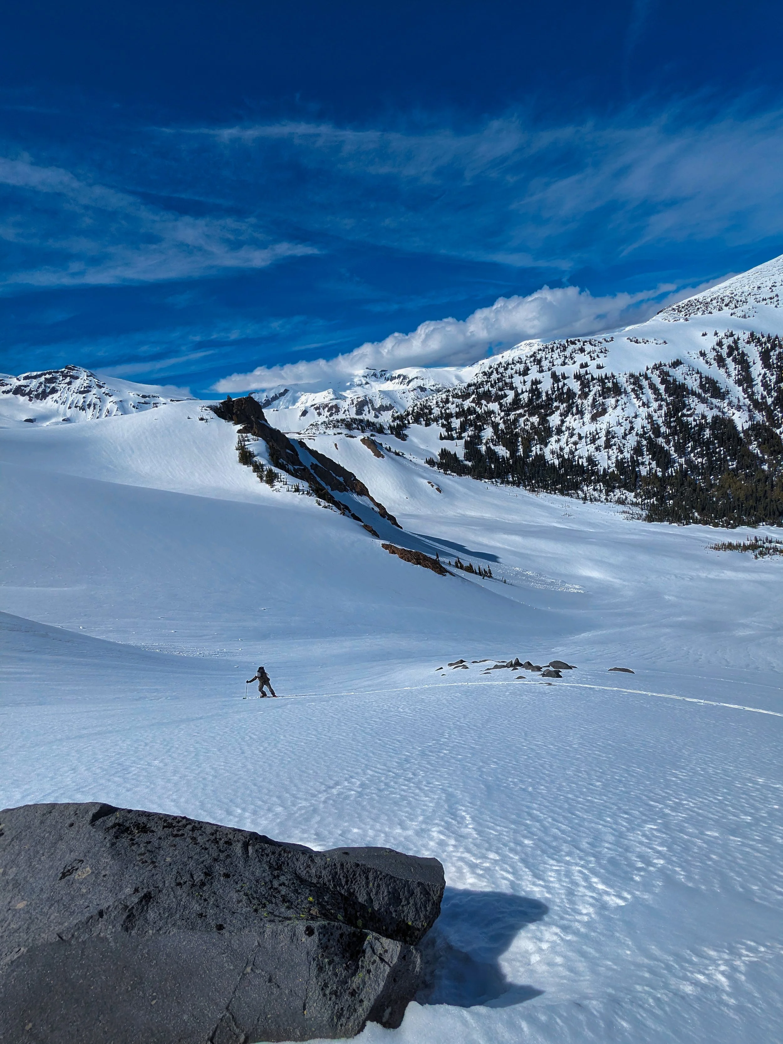
Yours truly lagging behind (photo by Peter)

I teamed up with Peter to venture into the still closed park for a ski outing. This time of year Highway 410 is closed to access the White River entrance, so we biked 410, being clear of snow, and were able to continue to the White River entrance and a little bit beyond, occasionaly pushing the bikes over snow patches until we finally ditched them and took to skinning the remaining 2 miles of road to the trail head.

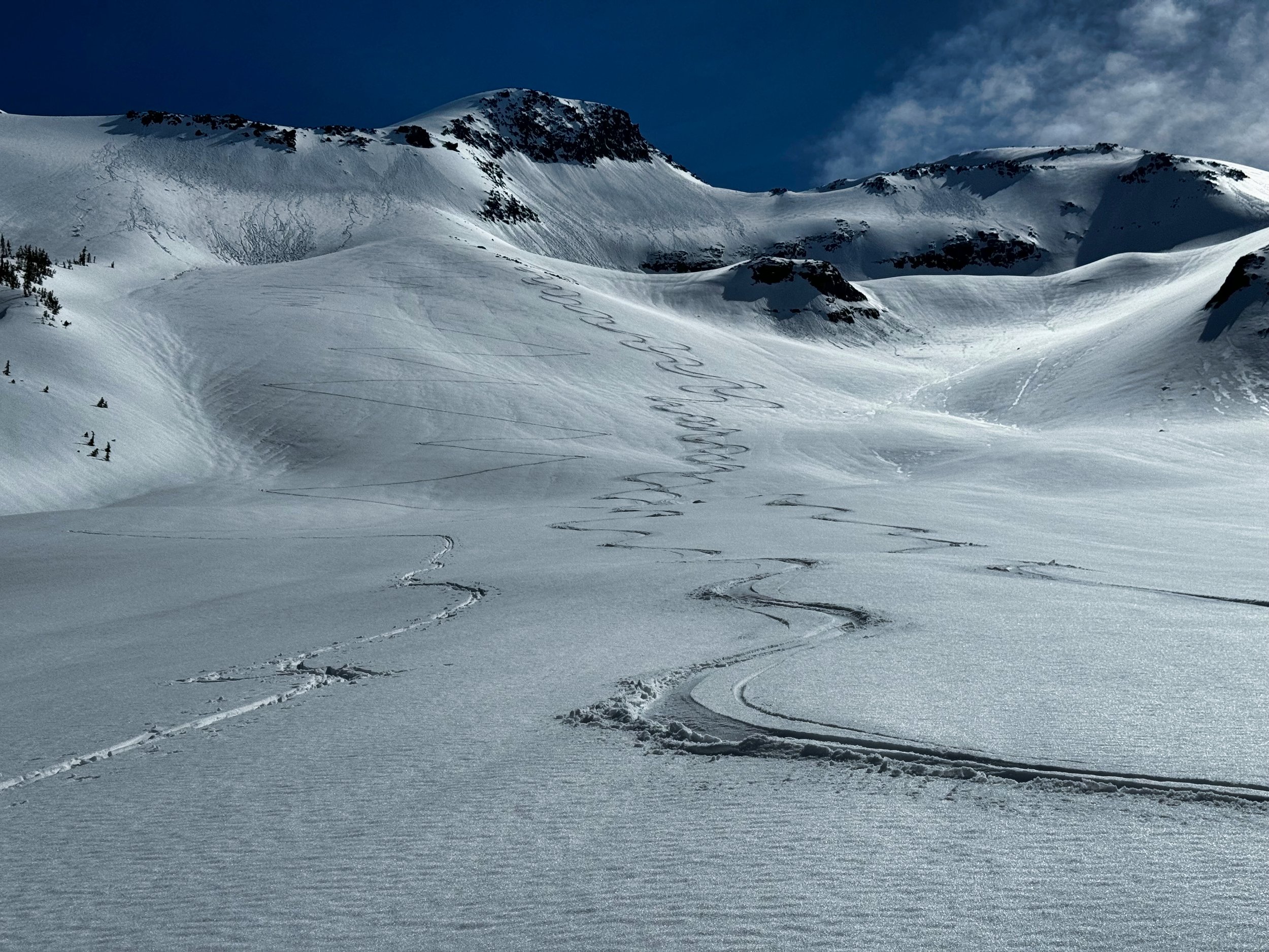
There is still enough snow to skin from the Fryingpan Creek trail head to Summerland, interrupted by negotiating creek crossings and snow covered bridges in the going. But the weather gods smiled upon us with mild temps and sunny skies; once out of the trees we were traversing a winter wonderland, untouched with the exception of bear tracks (which we followed for a time). Our original plan was to end run Summerland and continue up towards Panhandle Gap, but the beautiful slope ahead of us below Meany Crest beckoned with much better skiable terrain. Peter is a “young fella” and set in the skin track, forging ahead with ease. He has considerably more experience with backcountry skiing and I picked up some good tips and techniques from observing him and with direct inquiries. Our high point was 6600’ and we enjoyed wettish but smooth snow for a most excellent run. I elected to chill while he took another stab at it, and I watched him hammer up the track and be back within 20 minutes. Oh, to have that twenty something energy and strength again!

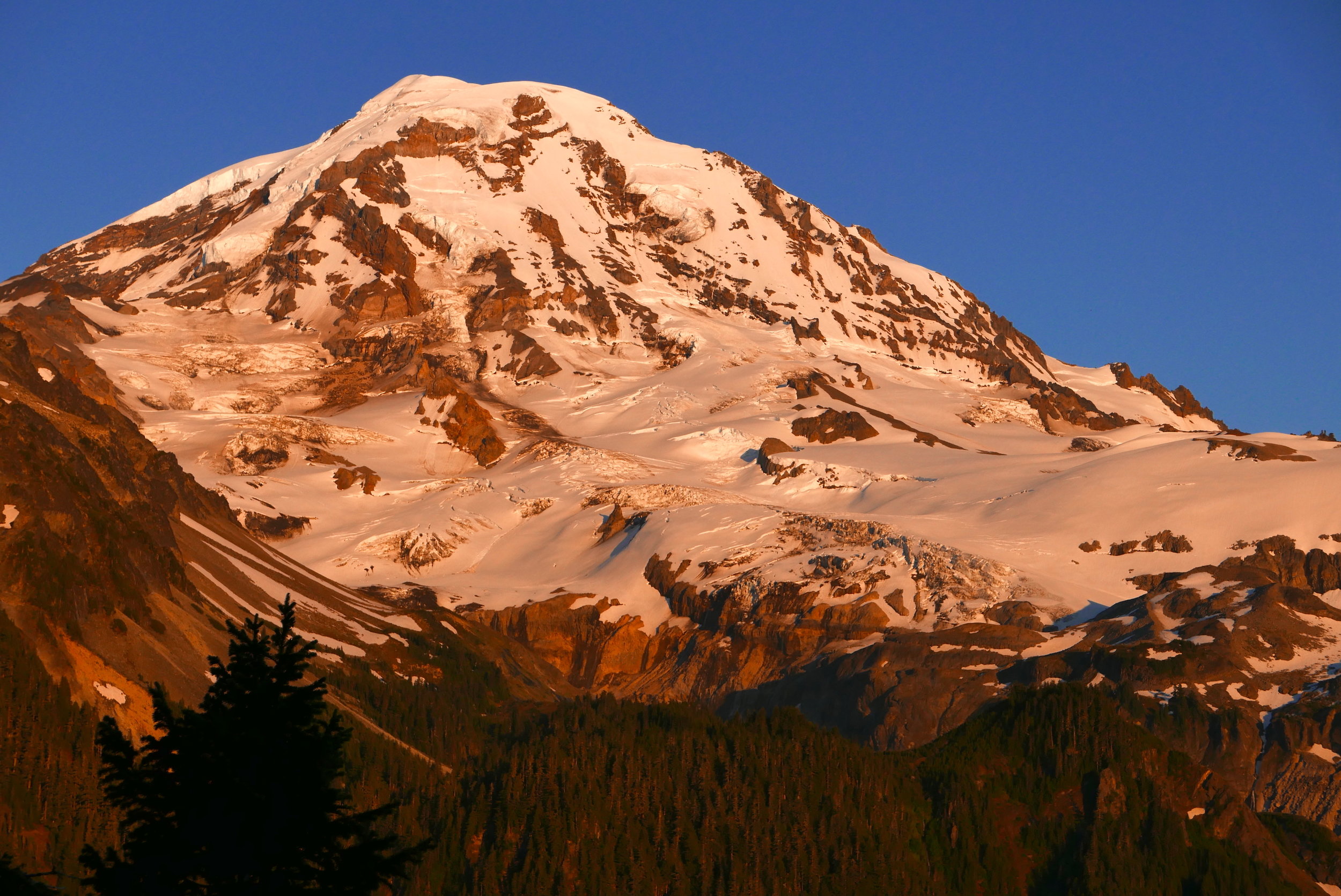
A winter wonderland in April, Mt. Rainier National Park

Once we got past the Fryingpan creek crossings and back onto our previous track, the going was smooth (exceptions of course: recrossing the creeks). It is amazing how much terrain you can cover just shushing along on skis on a gentle slope, faster than running pace. We eventually regained the road where, crossing paths with 2 other guys who also subjected themselves to this exotic experience of pain and pleasure, we free heeled back to the bikes without skins. Boy was I glad to get out of those boots after 10 hours, as they are not completely dialed in and I have to deal with a couple of hot spots. Back on the bikes a short climb got us to 410 and it was coasting all the way to our waiting vehicles, arriving at 8 PM with just enough light left to leave the headlamps in the pack. Stats for the day: 15 miles skiing with 4000’ elevation gain, and 14 miles RT biking adding another 1400’ of elevation for a total trip length of 29 miles and 5400’. Not the longest day I’ve had, but hard in that those other muscles not called upon for lift skiing were taxed for sure. Just another great day in the mountains!

April 17, 2024 /Willis Wall
meany crest mt rainier, skiing mt rainier, summerland mt rainier
Mt. Rainier's ice caps from the Russell Glacier

Mt. Rainier's ice caps from the Russell Glacier

SKINdependence Day 2017

July 05, 2017 by Willis Wall
skiing the Russell Glacier, Carbon Glacier below (upper left)

skiing the Russell Glacier, Carbon Glacier below (upper left)

Get those thoughts out of your head. On July 4, 2017 I hiked/skinned/skied the Russell Glacier in Mt. Rainier National Park. Ever since I did Observation Rock and a bit of Ptarmigan Ridge, I wanted to come back and tag a point above 9,000 feet and in the process get in some skiing. With just 4 hours of sleep after returning from overseas, I drug myself out of bed and packed up, hitting the trailhead at Mowich Lake just before 9 AM. Yes, that washboard road from Hell still sucks. There were just a few cars and people on this Skindependence day, and I crossed paths occasionally with 3 other skiers until we parted ways at the bottom of the Flett Glacier....they were heading over to do the ski from the headwall and I broke left to contour above Echo Rock to bake on the Russell Glacier. Aside from 4 day hikers, these were the only people I saw all day, and once I hit the Russell I had the park to myself. I have to admit that this was a long, tough day, entailing about 16 miles RT and over 5,000 feet of climb/descent.  It was very hot on the glacier(s), I spent a considerable amount of time schlepping my skis and boots, the terrain was sometimes challenging, and I ran out of water before topping out at 9510'. I resorted to eating some snow to keep my mouth from feeling like the Gobi, as no melting rivulets were to be found on the way up. The last stretch going up the Russell was steep enough to shed the skins and boot up, but the views were amazing from this height. The Liberty Ice cap and the top of Willis Wall look completely different because of the angle, closeness and altitude from such an interesting part of the mountain. Perched on Ptarmigan Ridge, one can survey the entire Puget Sound and gaze down on the North Mowich Glacier and the rugged Mowich Face above. The Liberty Cap ice fall looks like it could shed at any moment (I did record the tail end of a minor avalanche). One can look across during the climb or descent to Curtis Ridge, and on the ski down it was strange indeed to see the rubble-y Carbon Glacier stretched out below the fall line. Generally the snow was good and not too mushy, although somewhat striated....every turn crossed mini ridges for a bumpy ride but that didn't detract from my enjoyment of having this entire glacier and environs to myself. I skied lower than my ascent, which necessitated a short carry over to the Flett, and soon I found myself at the bottom of the run with a melt pool to slake my thirst. Although I had short cut the ascent from Spray Park over snow, I decided to continue down the summer trail for the descent, basking in perfect afternoon weather on heather during a snack break, sipping on ice cold water caressed from a tiny stream off snow melt to ensure I was rehydrated. The only sounds were wind and birdsong, and eventually I donned my clumsy and heavy ski and boot laden pack for the last push back to the vehicle. Spray Park is awash in avalanche lilies and speckled between with red, purple and yellow, but nowhere near the peak, there is still a bit of snow coverage in the meadows. As evening approached the mountain blazed with low angle sun through the trees, and I finally emerged from the woods at 9:40 PM, no headlight required. There's always a let down when the day is done, but I could tell I was really spent from the physical demands of the day. I was still able to enjoy fireworks on the ride out, especially in clear areas facing west to all the myriad towns from the Mowich road. Today defined the phrase "earn your turns", but this Skindependence Day was one of the best times I've had on the mountain.

Alpenglow from Eagle's Roost, on the hike out (July 4, 2017)

Alpenglow from Eagle's Roost, on the hike out (July 4, 2017)

July 05, 2017 /Willis Wall
skiing mt rainier, skiing russell glacier

© 2025 Willis Wall Multimedia

all rights reserved