Screw This!
When the going gets tough on the ungroomed, sometimes I dream of an easier way to get down. A Willis Wall short.
CELEBRATE THE OUTDOORS
40 years outdoors experience, extensive info on Mt. Rainier’s Wonderland Trail, original music, equipment reviews, off trail videos, other peaks in Mt. Rainier NP
When the going gets tough on the ungroomed, sometimes I dream of an easier way to get down. A Willis Wall short.
Just a bit early this year but a Happy Holidays goes out to everyone! I had a good year hiking (and biking) solo and with my daughter, and got out with my buddy Craig a few times. Places included: Mt. Rainier National Park, Mt. Hood, Mt. St. Helens, Mt. Adams, Alpine Lakes, Enchantments, and Olympic National Park. Please enjoy this video compilation from the past 10 months.

Zimmerbuilt packs on the Timberline Trail
This review is gonna be short and sweet. Chris Zimmer makes excellent packs, customized to your exact specifications. The workmanship is nothing short of outstanding. The response to emails was excellent, with questions being answered promptly and appropriate questions from Chris himself to nail down my needs. His prices are very reasonable. Once the specifications were finalized and the invoice paid, I had the packs in hand within a matter of days, not weeks. Here's the chronology of my experience:
• I asked for slight modifications to his standard Hybrid Daypack. Done. Paid. Delivered.
• I inquired about a custom front pack to match the Daypack. Perfect. I've been using it all season. The components are robust, meaning the strapping is wide and the buckles are solid, the attachment system is good for any pack I own, the zipper is rugged and the materials are tough (hybrid cuben).•
Pleased with this front pack, I ordered a completely custom backpack with these specifications:

Zimmerbuilt custom 1700 c.i. pack
- Hybrid Day Pack Body Style but larger volume
- Pack Volume - 1700ci
- Pack Material - Hybrid Cuben Fiber - Olive/Black
- 3D mesh padded back panel
- Foam Padded Shoulder Straps
- 3D mesh padded hip belt - minimal size
- Side Pockets - Dyneema X - Slanted top - Pleated
- 2 Side Compression Straps per side
- 2 Front vertical daisy chains
- Front Pocket - Mesh
- Ice Axe Loop - Left
- Zipper Pulls - 2
- Sternum Strap
- Haul Loop
Once finalized, I had this pack in less than a week.
• Noticing some wear on my clothing from front pack bottom attachment straps over the past few years,
I asked about slide on "mitigating rub pads". Done, delivered, tested and worked perfectly.
• Impressed enough with my pack experience,
I asked about a custom pack for my daughter:
- 2200ci ZB2 Style Pack

Zimmerbuilt custom ZB2 pack for my daughter
- Pack Dimensions - 11" wide by 7" deep by 22" tall plus the roll top
- Pack Material - Dyneema X
- Aluminum Stay
- Load Lifters
- Haul Loop
- Sternum Strap
- Foam Padded Hip Belt
- Foam Padded Shoulder straps with daisy chain
- Front Mesh pocket
- Front bungee cord compression
- 1 Axe loop - Left
- 2 Side compression straps per side
- Side Pockets (dyneema, pleated)
- Dry Bag Style Roll Top
- 2 Top straps for securing bear can if needed.
This was to be a "do all" pack, able to haul heavier loads if need be but not so huge as to preclude using it as a day pack. This was to replace a GG Mariposa, which proved uncomfortable at best with heavier loads. Used all season with excellent results. Sturdy. Perfect fit. Comfortable. Rides well when scrambling. Accommodating for large or small loads. Stylish. Great value. 'Nuff said.
I've used the smaller 1700 c.i. pack on most of my trips this season, including Mt. Adams Timberline Trail (2 days, 40 miles), the West 57 miles of the Wonderland Trail (2 days), a complete Wonderland Trail Fastpack (3 days, 93 miles) and a circuit of Mt. Adams along with numerous day trips of varying lengths. Scrambling. Running. 'Schwacking. Biking. Bashing. Snot bombs. Sharp talus. Scree. And I wasn't gentle. Of all the equipment I have purchased over the years, these packs rank among the best purchases I have made, including best bang for the buck. The most outstanding customer service. Best selection of materials for a combination of ruggedness and light weight. If you are experienced enough to know exactly what you want in a pack, buy a Zimmerbuilt.
Zimmerbuilt Custom Packs in use......

creek crossing on the Timberline Trail

crossing the raging Eliot Creek, Timberline Trail

Cassie cresting Crescent Gap

Zimmerbuilt pack in Joshua Tree National Park

lenticulars formed in unsettled skies
I had a choice today: go solo and knock off Echo and Observation Rocks at Mt Rainier National Park, completing the points on the Grand Tour. Or enjoying the day with my buddy Craig, who hasn't been out hiking in two years and is recovering from bronchitis. I chose the latter and I'm glad I did, despite the Mowich Lake road imminent closing in a few days, essentially cutting off easy access to this area for this season. I did manage one peak in the process, Fay Peak (6492') on the way to Knapsack Pass, which I practically sprinted up so as not to make Craig wait too long. I also left the trail in lower Spray Park to check out the saddle between Mt Pleasant and Hessong Rock, although climbing either of those peaks would have taken too much time while Craig was waiting. This was a great day overall, mostly from the camaraderie, theme based jokes and banter while enjoying decent weather. The hike was not so strenuous as to bring Craig to tears. His cough subsided as the day wore on, we took plenty of time to linger and shoot pix, the trail on the loop back was downhill and mild, and we made it to my vehicle just as it was getting dark. I've done a bit of solo hiking this year and just getting out with an old friend and inhaling nature's healing vapors was just the ticket. Check out the complete photo set.
This map shows the GPS track over Knapsack Pass via Fay Peak, at just over 5 miles and 3100 feet of elevation gain. The loop was completed on the main trail shown back to Mowich Lake for another 3.5 miles, making this loop a total of 8.5 miles long.
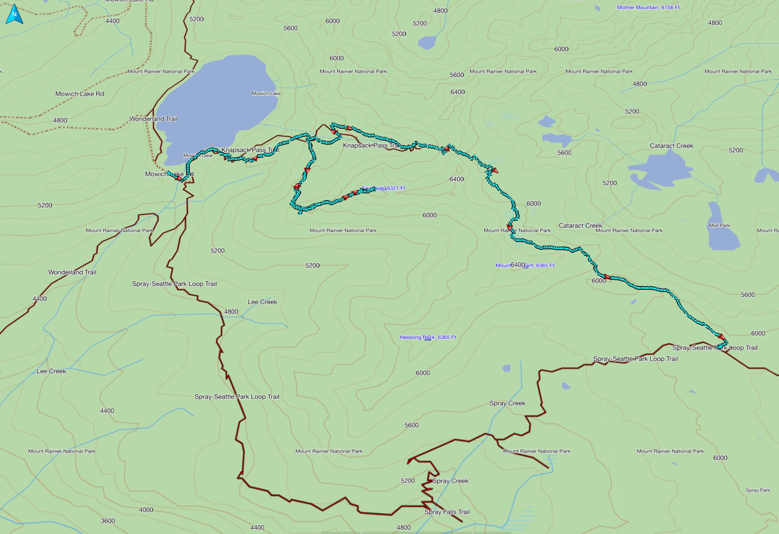
GPS track of Knapsack Pass/Fay Peak portion

fall on the Wonderland near Box Canyon
The weather had finally turned back to what might be considered more typical September Northwest fare, that of clear crisp days and generally ideal conditions. I decided spur of the moment to take advantage of these conditions on some days off to cap off this season with a thru hike of Mt. Rainier's Wonderland Trail. Yes, I know I have spent some time in the Mt. Rainier environs this season, but I haven't actually done a continuous Wonderland hike since 2009 for various reasons. My fitness was peaking, my gear was dialed in, and it didn't take me long to pack for this trip, planning on a max of 3 days with an open itinerary. Now, I've been a good boy and acquired permits for the park when needed this year, but for this trip it really wasn't necessary...I was playing it by ear, so to speak. I planned on perhaps stopping the first night at Mowich Lake campground, which is self registering and car accessible. Wonderland Trail Fastpack photo set

the mountain from Kautz Creek
Day 1, September 29: Longmire to Mowich Lake (35 miles/9500' elevation gain)
I started hiking at 8:15 AM from Longmire heading Clockwise on a trail so familiar by now (I have hiked the Wonderland about 30 times) that I wonder why I even bother packing a map. On this trip I took more documentary photos, meaning more diligence capturing creek crossings like Kautz and Pyramid, to compare to earlier years and as reference for the future. As an example, I reviewed video taken after the floods when I hiked the trail in 2007 and these crossings were completely devoid of any vegetation, yet now have alders growing at a rapid rate. The sky was completely clear and as usual I stopped at the ranger cabin at Indian Henry's Hunting Ground for a break and some chow. With this season having been so far ahead from the beginning (reference my hike on June 9/10) I found that fall colors are fading fast and most of the area looks ready for winter, with brown being the predominent hue. However, vibrant patches of reds and golds could still be found on this hike and I made sure to capture them on camera. Today reminded me how much I love hiking in the fall, despite shorter days and more reliance on night hiking when undertaking a trip of this length and difficulty where my days were expected to be in the vicinity of 17 hours. Luckily my body cooperated over the 5 significant climbs that would chacterize this first day, enabling me to enjoy all aspects of the reasons I get outdoors....physical toil, mental rejuvenation, smells and sounds and sights all rolled into one. I especially enjoyed the section transiting St. Andrews Park, despite temperatures that bordered on hot. I was amazed to see that there was still some water in Aurora Lake at Klapatche Park, although I suspect that it had been repumped by more recent rains and inclement weather preceeding my hike, rather than being left over from the entire season. After a significant break here I continued my 2500 foot drop down to the North Puyallup where it was time for...big surprise...another snack break. I tried to eat about every hour and a half to provide a steady stream of calories for this undertaking. From here I started yet another climb to Silver Forest, a place to gauge my progress based on sunset at this time of year. I determined that I was actually ahead of hikes I did even 20 years ago so was pleasantly pleased how I was holding up to this point. However, before the slight descent to Golden Lakes I had to turn on the lights and enjoyed glimpses of the glow of Tacoma from this side of the mountain. Many times I have stopped at Golden Lakes (25 miles to this point), especially if I'm doing a 4 day hike, but I forged on and committed to the 2500 foot drop to the South and North Mowich Rivers, which I transited (obviously) in the dark. As I passed the Mowich River Camp I noted that this would be my usual stopping point for a 3 day hike, but tonight I continued the grind up to the Mowich Lake camp, another 2300 foot climb and the last for the day. When I arrived at Mowich Lake I laid out my bivy on the concrete pad where the (empty) trash cans were, stashed my food in a food locker, used the vault toilet to clean up and bedded down at 1 AM, with my alarm set for 6.

hiker on the Tahoma Creek suspension bridge
Day 2, September 30: Mowich Lake to White River (25 miles/6000' elevation gain)

low angle sun near Skyscraper Pass sets the meadow aglow
As usual I missed my alarm and woke up to already light skies, but managed to get on the trail by 7:30 AM. There were a few cars in the lot and one tent set up in this most inglorious campground. I took physical stock on the trail and was pleased that my legs were cooperating nicely as I started out on the first miles. Mowich Lake was like glass and when I reached Ipsut Pass the sun was blazing on the rock faces and setting the gold bushes aglow. One of the benefits of doing this trail in the fall is one doesn't have to contend with trail disguising overhanging brush, so my descent into the forest proper was accomplished without hidden rock obstacles causing near face plants. The hike through the old growth was back in cool shade and abundant with flowing water and waterfalls, quite pleasant indeed. What's not pleasant is noting how much elevation I was losing, bottoming out at 2400 feet elevation, as I knew a steady 3600 foot grind-climb to Mystic Pass was in my immediate future. I had to remind myself that this trail throws all kinds of obstacles to pleasantness at you...rocks, roots, huge steps up and down, gravel over rock, muddy trail and so on, and this is just part of the agreement. Suck it up and enjoy the surroundings, and that's exactly what I did. This proved to be another warmish day and I welcomed the less heat producing trek down from Mystic Pass, stopping again at Mystic Lake for another break. On this occasion the sun was beating on my face but I didn't mind and enjoyed the gently lapping waves on the miniature beach as I munched away. This season I've been on this section 4 times already but no matter, familiarity is not a detriment to enjoyment. After a quick stop at Granite Creek camp I predicted that I would be able to transit most of the area around Skyscraper Pass when it was still light, and this proved to be. Near Skyscraper Pass the area above treeline absolutely glowed golden in the low angled sunlight for a scene I hadn't witnessed before. Even after 30 times I can always count on pleasant surprises. But as the sun set, my lack of sleep over the past 3 days was catching up with me, manifesting itself with this strange urge to lie down and take a little nap. At this point, before Sunrise, I decided to stop for the evening at White River after only 25 miles and just sleep as long as I needed. It was still rather early for me and I set out my bivy on the side porch of the White River cabin at 10 PM and closed my eyes.
Day 3, October 1: White River to Longmire (33 miles/6100' elevation gain)

one of the best vistas in the park: the area above Indian Bar
The skies were light when I awoke, but that was OK as I finally felt rested. No one was to be seen, the campground was closed and there were only 2 cars in the overnight parking lot. However, the facilities were locked and the water was shut off, so I had to go to the still open vault toilet at the campground entrance for my morning chores. I expected this and still had plenty of water so I cleaned up and headed off for the high country, hitting the trail at 7:30 AM once again. I knew I had a long day ahead of me as I wasn't able to capitalize on my extra mileage on day 1 (for a 3 day trip) due to my short day yesterday. Once I started up the trail I knew my decision was a good one as my body and mind were showing their appreciation for some recovery time. As expected, I ran into some day hikers around Summerland and even Panhandle Gap, but once beyond there I had the trail to myself. Besides, I had pleasant conversation with some and this is all part of the Wonderland experience. It was warm again but I certainly wasn't going to complain, considering the weather my daughter and I contended with in August and the first part of September. I was reminded once again that no lens can capture the grandeur of some of the vistas along the trail, in this case an overlook (above 6000 feet) of the Ohanapecosh valley leading to Indian Bar, hearing the distant whoosh of the cascading myriad waterfalls marking the headwaters of the Ohanapecosh River. An inspiring sight indeed. I noted some further wandering of the river as I neared Indian Bar and took refuge from the sun in the newly shake-clad cool stone shelter there. For some time I had the place to myself until two lads showed up who were doing 59 national parks in 59 weeks, truly a very cool trip. We enjoyed some pleasant banter for awhile but then I was off to finish up another 21 miles for the day. At least the remainder of the trail was benign by Wonderland standards and I made it past Box Canyon still under natural light. Perhaps the one thing I regret about doing Stevens Canyon in the dark is missing the fall colors of the understory, usually fantastic here at this time of year. However, it seems my recompense was Reflection Lake, where a low cloud deck quickly parted to reveal the moon's reflection glistening on the water with both the original and copy surrounded by an orange halo. I enjoyed this in complete solitude despite being right next to the road. After this it was a matter of lasting to the end without my old bod blowing up from the strenuous days behind me, arriving at my vehicle at exactly 1 AM, very satisfied that I could still pull off a 3 day Wonderland hike more than twenty years after I did my first.
If you'd like to read my thoughts on doing this at age 60, go here.

a different reflection on Reflection Lake

pano on the Success Divide at 7800'
It seems with current weather trends that I am not going to be able to complete the last part (West) of the Mt. Rainier Grand Tour in one shot, as forging high on the divides and cleavers really should be done in good weather to take advantage of expansive views. A short decent weather window allowed me to at least get up the Success Divide to 7800 feet on Wednesday, September 23, and allowed for expansive views south and west, but a lingering cloud layer over the mountain proper down to about 8000 feet blocked any views upward. Nevertheless, this was a highly rewarding and somewhat tough day. The straight forward part is following the Wonderland Trail from Longmire to Indian Henry's Hunting Ground, and there is a well established trail leading to Pyramid Peak from the Mirror Lakes Trail. After this, travel becomes somewhat more complicated as one skirts the base of Pyramid Peak to acquire the Success Divide. This is one instance where I actually was glad to have a GPS to check my return track a few times in this section. See the complete photo set for this Success Divide hike here.

fall colors near Pyramid Peak
The Success Divide is the lower part of a ridge that leads to the Success Cleaver. This is the only climbing route on Rainier that doesn't step foot on a glacier, but it is long and tough. As part of the Grand Tour I wanted to climb high enough to get close up views of the South Tahoma Glacier, Glacier Island, and numerous peaks to the west and south. Travel on the Divide was fairly tough, with loose rock and scree combined with route finding to choose the best line whilst skirting steeper areas. When I think of all the different areas and off trail portions of the Grand Tour, this was perhaps the toughest after the Elysian Fields/Moraine Park transit. However, it fits well in the crafting of my self concocted Grand Tour, taking the intrepid hiker well beyond the manicured trails in the park to areas visited by (statistically of all hikers) the few. And keeping in line with my criteria of non technical travel and/or specialized equipment, climbing the Divide was done with my usual light trail runners, in this case Inov8 Trailrock 235s.

tarn below Pyramid Peak
By dividing the West portion of the Grand Tour I am actually putting in many more miles than the original plan of 150, but so it goes. This day didn't disappoint on this first day of fall, with some patches of vibrant fall colors, cool temps, and solitude once I left the Wonderland. On my way back there was a one camper at Devils Dream camp, and I enjoyed perhaps 30 minutes of comraderie and libations while the chap from Wisconsin was making dinner, a pleasant respite indeed. After that it was a matter of retracing my steps in the dark back to my vehicle in a mostly downhill trot, enjoying the moon peeking through the trees in the process. Despite the weather not cooperating in its usual September style, snatching days like this when the opportunity arrives is still a treat for the soul.
Little Tahoma, Mt Rainier, Steamboat Prow and the Inter Glacier from Mt. Ruth (8695')
The first snows of the season hit some upper reaches recently, making me realize the time may be drawing short for finishing up the Grand Tour. With a few days of pristine weather prior to the end of my vacation, I finished the north section in one push of 33 miles and 10,600 feet of elevation gain and loss. After hiking for nearly a week in so so weather (Alpine Lakes), this day, Wednesday September 9th, proved to be one of the most incredible and satisfying days I have spent in the mountains. If I had one word to describe this experience it would be Glorious. Grand Tour Part 3 photo set here.
The points I chose for this part of the park continue to be representative of in-your-face glacier views, solitude from crowds, strenuous but not technical off trail travel and fabulous 360 degree vistas. The order and days traveled are irrelevant, but here are the points that I hit:
Mt. Ruth (8690') and slightly beyond (8750')
Third Burroughs Mountain (7828')
Skyscraper Mountain (7078')
Curtis Ridge (7000-8000')

next objective Third Burroughs in sight
For my long day I chose to start at the White River campground and proceed up the Glacier Basin trail to Glacier Basin. From there I easily crossed the Inter Fork of the White River by rock hopping and proceeded to scale the ridge further right, skirting some cliff bands but attaining the ridge higher than the usual climbers trail, which I used for the descent. Some fresh snow deposits on Ruth were easily negotiated in my trail runners and I enjoyed solitude on this summit with 360 degree views, spying many points (such as Goat Island Mountain, Banshee etc) that are also on the Tour. The Emmons Glacier is so massive that no camera can capture its immensity, nor can panos do the view justice in any direction. This is truly a place that needs your eyeballs for it to sink in. I finally tore myself away from the summit to proceed up the spine towards Steamboat Prow but was met by a rocky barrier barring access to the rest of the ridge. It seems the other times I have been up here I came via the Inter Glacier so perhaps hadn't noted this. I descended at this point a bit to see if I could scramble around but quickly decided that I should bag it and head back. It is still worth it to hike the spine this short ways to look back on the dramatic side of Mt. Ruth and stand approximately 60 feet higher than the Ruth summit. From here on it was downhill mode and I quickly found myself back at Glacier Basin and ready for the next ascent to Third Burroughs. This is all on trail and the view from Third Burroughs allows you to glimpse the other spine of Steamboat Prow and gaze upon the equally impressive Winthrop Glacier. I looked towards my next objective, Skyscraper Mountain, and scoped a cross country route that would take me there. This off trail section went without much difficulty and once I attained the open ridge it was an easy walk to intersect the Wonderland Trail at Skyscraper Pass and follow the obvious tread to Skyscraper Mountain. Once again I had the summit to myself and enjoyed equally impressive 360 degree views, spying more points on the Tour. From this point I joined the Wonderland Trail with the aim of making Mystic Lake before nightfall. The only glitch in my plan was a socked in Curtis Ridge, where I have been many times before, and I decided to skip foggy nighttime cross country travel here with questionable returns. I was carrying everything I needed with the plan of attaining Curtis Ridge and snoozing until sunrise for photo ops, then hiking out to be done before noon, but I decided to skip right to the return to reacquaint myself with endurance hiking and star gazing. It made for a long day but extremely satisfying being able to pull off this hike in this age 60 celebratory year.

Mt. Ruth from higher up on the ridge leading to Steamboat Prow

Mt. Ruth (center) on climb to First Burroughs Mountain
Whether I can finish the last part of the Tour (South) before winter sets in is up to the vagaries of weather and schedule. Once complete I will publish more particulars and possible ways to connect these hikes for the intrepid backpacker who wants to experience this park in ways far beyond the Wonderland. Stay tuned.
The Alpine Lakes Wilderness is nestled in Washington State's Central Cascades region, consisting of 394,000 acres of glacial scoured wonder. My daughter and I spent a week transiting and exploring some of this area, albeit during a period of unsettled weather. Damp skies didn't dampen our spirits and in fact, unsettled weather makes for uncrowded trails, even at the end of summer. The following 4 trips totaled 75 miles of hiking, barely scratching the surface of this pristine wilderness.
Icicle Ridge (8/27-28)
sunset at Lake Grace
With iffy weather forecasts all over, my daughter and I were trying to work around possible weather, and we got really lucky on this one. We hiked from the Icicle Creek trailhead to Lake Grace on day 1, leaving us plenty of time to lounge before dark and scope out a possible foray to Upper Grace Lake, a nasty looking scramble from our vantage point. She had about 4 possible choices for day two and we agreed if the weather was good on the second day we would get up early and go for the upper lake. However, it started raining and continued through most of the night, so we stayed in for awhile and got up when it seemed to abate. We decided to continue on a shortish loop for day 2 and do as much as we could before the rains started, but the forecast rains never came and we enjoyed a dry day. We enjoyed solitude until the last part of day 2 when we ran into some hikers up around Lake Edna. We were somewhat baffled by one couple who were scantily clad with one small pack asking if the parking lot was up here (at the time we had just crested a pass at 6800 feet). They had climbed the Chatter Creek trail over 4000 feet...??? We showed them the map and pointed out that whatever the ranger told them about a 10 mile loop something was amiss, so they reluctantly turned around and descended the very steep and unrelenting trail back the way they came. We were wondering if they were still going to be a couple the next day. This trip was approximately 28 miles with some pretty good pulls both uphill and down. Overall we thought the scenery was spectacular and ever changing.

colors reflect in Lake Mary
Kendall Katwalk (8/30)
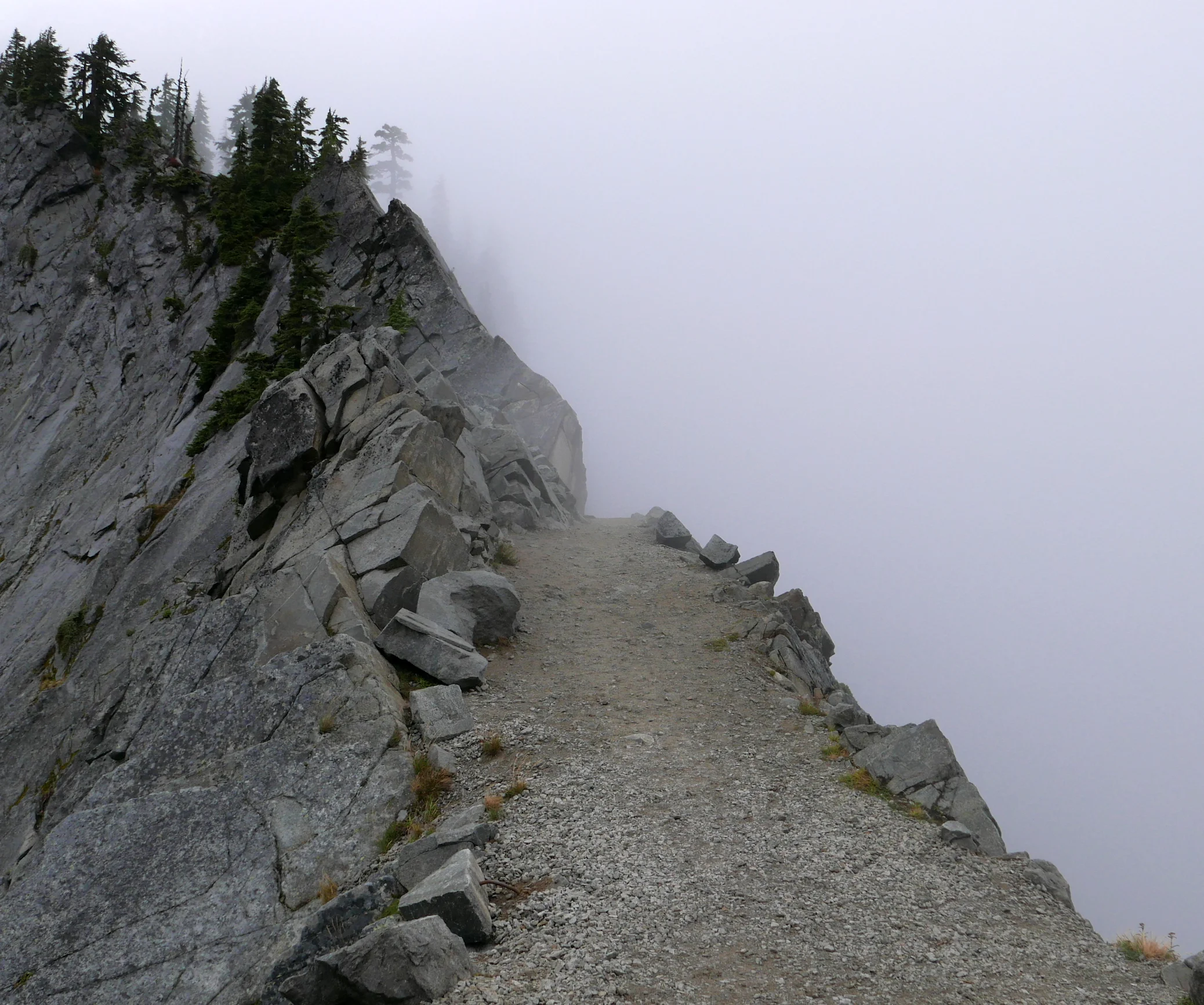
Kendall Katwalk in mist
Just up the road off I-90, this 12 mile round trip with 3000 feet of elevation gain and loss is a great trainer for keeping the legs loose, plus it takes one to one of the more unique spots in the Alpine Lakes Wilderness on the PCT, the Kendall Katwalk. This part of the trail is blasted into a sheer rock face with a thousand foot drop, pretty cool when you can see but very eerie when the clouds obscure the drop as was our case. It was cold and wet above 5000 feet and we didn't linger long, although staring into the white abyss was somewhat mesmerizing. We retreated around a corner and ate a quick snack before stoking the internal furnace and bringing feeling back into our fingertips on the way down. Before the relatively short drive home we stopped for hot chocolate and coffee, discussing how the summer seemed to come to an abrupt halt and give way immediately to winter like conditions, sans snow.
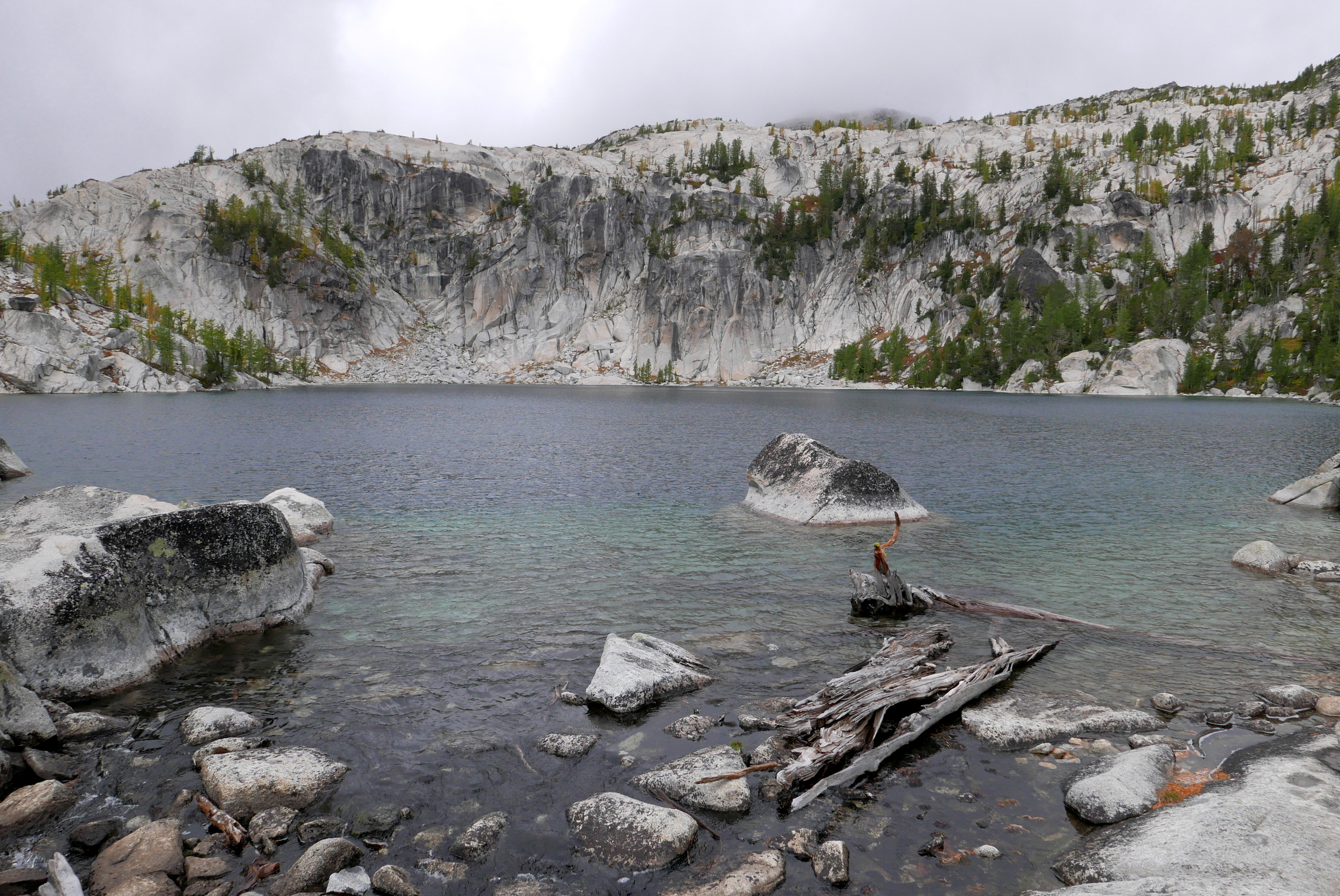
Enchantments (8/31-9/02)
Our first trip to the Enchantments found them virtually empty, probably because of 65 MPH winds and forecasts of snow. Some rangers told us people were bailing left and right. However, we had our permits so we were bound to take a looksee. Starting at the Snow Lakes trailhead, we began our 5000 foot climb with cloudy skies but no rain, eventually passing said rangers and then a group of 7 older campers. Quite a delightful group indeed, with whom we would cross paths the next day. There were a few other groups leaving or camped at Nada Lake but after this we would only see a couple running the transit. When we reached Snow lake at 5400 feet we took a break and discussed our options with the iffy weather forecast, where we decided to pitch our camp amidst a sheltered spot. If we had continued on from here, the next available option would have been at Leprechaun Lake at 6700 feet. We settled in for the evening, digging into our extravagant food selection and hunkered down for the night.

goat above Nada Lake

the larches are coming!
On Day 2 we got up after a very windy night and decided to leave the tent where it was and go up to explore the upper Enchantments on an out and back. If the weather turned out to be decent our plan was to tag Aasgard pass and then come back. However, once above 6000 feet we were met with driving mist most of the day and much lower temperatures, although the forecast snow was absent. Photo ops were few as just taking the camera out had to be with my back to the wind, but we still enjoyed the breathtaking surroundings wrapped in our 3 layers. I packed two cameras, one with a good telephoto for all the goat shots I anticipated, but even the goats had abandoned the upper reaches and the few shots I took lower down were the only ones to be had. Once we reached Perfection it was close to 2 PM so we decided to turn back and get over the slippery granite well before dark. Much to our delight the weather lessened its onslaught, the rains abated and the winds calmed and the descent from over 7000 feet back to our camp was almost pleasant. This entire day we saw 4 people, a couple of couples who were transiting from one trailhead to the other....not one occupied campsite was to be seen, possibly a rare event for this time of year. Once we reached Snow Lake we ran into our relocated group of 7 and chatted with them again, lamenting that we had no hot chocolate so two cups were produced for us...it's nice to have a daughter around with big eyes just glowing with hot chocolate neediness.
Lake Viviane

lower trail to the Enchantments
Back in our camp we pondered the next day but my wife was texting the weather forecasts (via DeLorme) and high winds, snow and even thunder quelled our ambitions to ascend for a second day. In fact, most of the night the gusts were loud and strong enough to keep me awake at first, assessing the tent's ability to withstand what made it through the trees as my daughter snored beside me. I was quite glad we were not camped at 7000 feet that evening for sure. We awoke to sunny skies, lingered in the chill for awhile and met lots of people coming up the trail with the sun beating down. I hope the weather treats them well despite the forecasts. Our plan is to return next year and endure hot weather or perhaps at least transit from Aasgard across in one shot, it really is a special place that lives up to the hype...especially when it is uncrowded.

general area map of areas explored in the Alpine Lakes
Rachel Lake, Alta Mountain (9/05)

Rachel Lake
Labor Day weekend had a forecast for one decent day and we tried to take advantage of it by climbing Alta Mountain (6150'). A short 3.5 mile hike took us past Rachel Lake, then a 2.5 mile steepish pull put us on the Alta summit. However, the weather didn't cooperate with any views so we enjoyed white out conditions and biting winds, descending after tagging the summit to a nice sheltered area for lunch. Considering the thunderstorm that greeted us when we arrived home, I have to say the weather cooperated nicely with no rain and about 6 ten second periods of sun. Expansive views would have been a bonus, but we thoroughly enjoyed this outing of perfect length and difficulty (12 miles/3300'), close access (just over an hour's drive) and crisp fall air. It seems we have only touched the surface of possibilities in this gem of wilderness that lies so close to the Seattle area.

fall colors below Alta Mountain

approaching Alta summit (6150')
 our route across the Elysian Fields and Moraine ParkI’d venture a guess that the majority of people hiking Mt. Rainier’s Northern Loop Trail are unaware that they are orbiting one of the most pristine and picturesque areas of the park, guarded on all sides by tall ramparts that shield it from the hiking masses like a lost world.