2 Rare Transition Hikes
DeLorme map with position report timesHIKE 1: (12 miles/3000')
When I write rare, I mean the opportunity to do a great hike in weather that seasonally is not so cooperative. For October, this turned out to be on the 19th. My daughter was home for a few days from school and was craving a taste of North West outdoors, it didn't matter if it was in rain, she just wanted to get out. Staying within a two hour drive, we traveled to Mt. Rainier National Park to try something new, a loop hike starting at Mowich Lake that would take us up above 7000 feet with a possible summit of Observation Rock if time allowed.
Mt Rainier: Pyramid Peak
40 Hours on the Wonderland Trail
time map for position reports on the WTThis trip had an interesting start, as I was back from London without much sleep and decided to take advantage of good weather on Monday and Tuesday (Sep 15-16) to head out. But first I was supposed to pick up some new pants from Beyond Clothing, and waited at the Seattle store for the UPS truck to arrive with said trousers. As I finally had to head out the door from the no show truck, they sent me to their warehouse in Kent to pick up a pair on the way to the mountain.
Mt Rainier: The 7Up Hikes-Tokaloo Rock Loop
This is the last in this year's "7Up Hikes" series. My goal of hikes around Rainier taking advantage of off trail segments and touching points above 7000 feet certainly delivered a unique and different experience of the park beyond the Wonderland. That said, this last hike (September 10th) I ended up scaling back quite a bit as the original included another high point on a cleaver and 41 miles of hiking and biking, probably too much for this old man. This one was juuust right, doable in 12 hours: Stats: 25 miles (8 miles biking)/5300' elevation gain and loss.
Mt. Rainier: The 7Up Hikes/Curtis Ridge-Old Desolate "T"
Curtis Ridge/Old Desolate "T"Get ready for a spanking on this one, as it provides 26 miles and 8200 feet of vertical, the hardest parts off trail. It took me nearly 17 hours to complete. This is the third in a series of hikes I planned for Mt. Rainier National Park where vistas above 7000 feet and off trail travel let one experience a whole different world outside of the Wonderland Trail. Although already planned, the timing was spur of the moment.
8 Days in the Pasayten Wilderness-Aug/2014
from the DeLorme map of positions reports sent on tripOverview
Originally planned as a 200 mile trip, my daughter's recovering hip, rehabbed enough to get the go ahead for hiking, had us entering this foray with different criteria: plan on 10 days max and venture into the heart of the Pasayten wilderness as far as current fires, physical limitations and trail conditions allowed before looping back. The meager stats (101 miles, 16,000' of elevation gain) don't do justice to the difficulties we faced….pea sized hail and thunderstorms at 7000', trails and phantom trails with meager tread, river crossings, soaking head high grasses and fireweed leaving our lower bodies in a constant state of saturation, and hundreds of blowdowns and deadfall to name a few. But what a trip!
Mt. Rainier: The 7Up Hikes/Goat Is.-Banshee Loop
Goat Island Mountain to Summerland sectionThis is a big hike with big views. I recruited my buddy CB for this one as the extensive off trail and planned exit warranted a partner for safety. As it turns out the gnarly exit was bypassed, more on that. This trip provides 17 miles and 5600 feet of elevation.
We parked at the Fryingpan creek trail head and spent a very short time on trail, taking a right on the Wonderland for less than half a mile and proceeding off trail at the obvious bend. This lower part of the ridge for Goat Island is of course treed but manageable enough and eventually the terrain opened up into some meadows
Mt. Rainier: The 7up Hikes/Ruth-Burroughs Loop
The Ruth-Burroughs loopRecently I sat down with a map and looked for different ways to explore Mt. Rainier beyond the Wonderland Trail and such. My criteria was as follows:
• maximize climbs to points over 7,000 feet (usually with great views)
• no specialized skills; no glacier travel, no roped climbing
• looped hikes if possible, off trail travel encouraged
• tough hikes but doable in a day by fit experienced hikers; max 2 days
• hardest parts in the first half of the hike
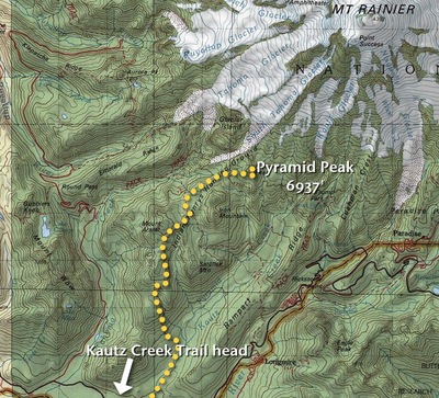
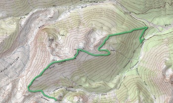
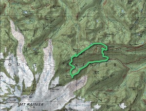
My daughter and I just did the first of the series, the Mt. Ruth-Burroughs loop. This hike starts and ends at White River campground and entails approximately 17 miles of hiking and 5900 feet of elevation gain/loss, plus much of the hike is off trail.
STP (Seattle To Portland) 2014 bike ride
This is the second year my buddy Craig rode the STP so I mounted a Contour Roam2 to my front fork to capture the experience for him. The first day was very hot, into the 90s, but the second day saw cooler temps and even some rain. Over 10,000 riders sign up every year and about 2200 do it in one day. Centralia, WA is the halfway point where many people spend the night. I find biking to be an excellent cross training tool in my fitness regimen, although I do have a tradition of only doing one major trainer before this event. Let's just say my derriere and neck muscles bear the brunt of my undertraining.